man of the late 20th century.
- Главная
- Разное
- Дизайн
- Бизнес и предпринимательство
- Аналитика
- Образование
- Развлечения
- Красота и здоровье
- Финансы
- Государство
- Путешествия
- Спорт
- Недвижимость
- Армия
- Графика
- Культурология
- Еда и кулинария
- Лингвистика
- Английский язык
- Астрономия
- Алгебра
- Биология
- География
- Детские презентации
- Информатика
- История
- Литература
- Маркетинг
- Математика
- Медицина
- Менеджмент
- Музыка
- МХК
- Немецкий язык
- ОБЖ
- Обществознание
- Окружающий мир
- Педагогика
- Русский язык
- Технология
- Физика
- Философия
- Химия
- Шаблоны, картинки для презентаций
- Экология
- Экономика
- Юриспруденция
Prospects for the development of GIS in the representation of a man of the late 20th century презентация
Содержание
- 1. Prospects for the development of GIS in the representation of a man of the late 20th century
- 2. Introduction Recently, processes all over the world
- 4. In addition, this process, in addition to
- 6. State of development of GIS GIS is
- 8. GIS - technology or the worldview of
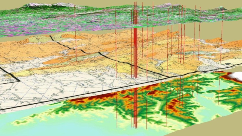
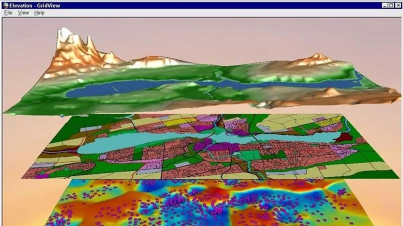
- 9. An example of dividing a map into several layers:
- 10. The third direction of GIS development is
- 12. Conclusion Summation of the same capabilities of

Слайд 2Introduction
Recently, processes all over the world and in Russia have been
observed, which largely reflect the current trends in the development of society. They are connected with the wide introduction of information technologies and information services, penetrating into all spheres of human activity. In the West it has long been recognized that humanity has entered the information stage of its development. And this stage, according to experts, has a huge impact on the changing of modern human life and human development. This was also confirmed by the meeting of the heads of state of the Big Eight in Okinawa, where the greatest attention was paid to information technologies and their influence on the modern world.
Information technology includes work with huge volumes of information, speed and availability, wide distribution and scalability in different conditions. All this leads to the fact that a large number of specialists and users from different areas and fields of activity have, to some extent, mastered them or are at the stage of development and implementation into their work.


Слайд 4In addition, this process, in addition to special areas, goes in
other areas of human activity. And first of all I would like to note the sphere of education, in which hundreds of millions of people all over the world are involved. The peculiarity of this process here lies both in the adaptation and retraining of already established specialists in information technologies, and in the training and education of a new generation of people entering the labor life, starting it in the information stage and getting an idea of the world in general and modern information technologies in particular. And their views, their attitude to what is happening in the world and within it, their approaches, differ to a considerable extent and a new worldview. Or rather, initially based on its fundamentals. And sometimes those who are only adapting to the new conditions, but have the old baggage of knowledge and views and the old vision, it is not always clear. And we, based on our old concepts and views, sometimes do not notice that the new is already rapidly entering our world and our everyday life. And that the modern generation takes it quite differently.
Against this background, in modern conditions, it seems interesting to consider the development of geographic information systems and GIS technologies and the trends that they face in modern conditions.

Слайд 6State of development of GIS
GIS is a science combining the theory,
methods and traditions of classical cartography and geography with the possibilities and apparatus of applied mathematics, computer science and computer technology.
On the basis of information technology in the 60s of the XX century in the bowels of the Pentagon, a direction appeared, later called GIS or geographic information systems. It combines the solution of the necessary applied tasks with the capabilities of a person, a computer and software that processes spatial information and transmits it to the consumer on a monitor screen, a printer or on communication channels.
So in the beginning were born digital cartography and automated mapping, supplemented with time by other numerous functions and capabilities and are the basis of any GIS.
Since the 1970s, GIS has become a commercial product that is beginning to be used not only in the military, but also in other fields of knowledge.
In the 80's and 90's, after the emergence and mass use of personal computers, GIS is gradually capturing all new world markets and appears in the USSR, and then in Russia.
Today GIS is advancing all over the world on a very wide front in various directions. Sales volumes of GIS products and GIS-technologies, as well as provided GIS-services annually increase by 20-30% and reach several billion US dollars per year. And tomorrow this trend will intensify even more.
GIS was created primarily for geography and geography, but now in the West GIS is used in a huge number of management structures, in various firms, in enterprises, in military departments, in scientific and educational institutions. GIS-systems and GIS-technologies have found very wide application in various spheres and directions of territorial activity.
GIS was created primarily for geography and geography, but now in the West GIS is used in a huge number of management structures, in various firms, in enterprises, in military departments, in scientific and educational institutions. GIS-systems and GIS-technologies have found very wide application in various spheres and directions of territorial activity.

Слайд 8GIS - technology or the worldview of the XXI century???
Characteristics
of modern trends in GIS development
It is important to note that GIS is now combined with another powerful system for obtaining and presenting geographic information - Earth remote sensing data (RS) from space. Space information in today's world is becoming increasingly diverse and accurate. The possibility of obtaining and updating it is more and more easy and affordable. Dozens of orbital systems transmit high-precision space images of any territory of our planet. Abroad and in Russia archives and data banks of digital images of very high resolution to the vast territory of the globe are formed. Their relative accessibility to the consumer (online search, ordering and receiving via the Internet), surveys of any territory at the request of the consumer, the possibility of subsequent processing and analysis of satellite imagery using various software tools, integration with GIS packages and GIS systems, transform the GIS tandem -DZS into a new powerful tool of geographical analysis. This is the first and most real direction of modern GIS development.
The second direction of GIS development is the joint and wide use of data of high-precision global positioning of an object on water or on land, obtained with the help of GPS systems (USA) or GLONASS (Russia). These systems, especially GPS, are already widely used in marine navigation, aeronautics, geodesy, military affairs and other branches of human activity. Their use in combination with GIS and ERS form a powerful triad of high-precision, up-to-date (up to the real time mode), constantly updated, objective and densely packed with territorial information that can be used almost everywhere. Examples of successful joint use of these systems by NATO troops in the conduct of hostilities in the military conflicts in Iraq and Yugoslavia are proof that the time of wide dissemination of this direction in other areas of practical activity is not far off.


Слайд 10The third direction of GIS development is related to the development
of the telecommunications system, primarily the international Internet network and the massive use of global international information resources. In this direction, several promising paths are seen.
The first way will be determined by the development of corporate networks of the largest enterprises and management structures that have remote access, using Intranet technology. This path is supported by the serious financial resources of these structures and the problems and tasks that they have to solve in their activities using spatial analysis. This way, most likely, will determine the development of technological problems of GIS when working in corporate networks. Spreading the same technology to address the issues of small and medium-sized enterprises and firms will give a powerful impetus to their massive use.
The second way depends on the development of the Internet itself, which spreads around the world at a tremendous rate, involving tens of thousands of new users every day in its audience. This path leads to a new and as yet unexplored road along which traditional GIS from usually closed and expensive systems existing for individual teams and solving individual tasks acquire new qualities, unite and become powerful integrated and interactive systems of joint global use.


Слайд 12Conclusion
Summation of the same capabilities of GIS - RS - GPS
- Internet
will be a powerful quartet of spatial information, new technologies, communication channels and services that will be implemented both in the Global GIS, which has various unique capabilities, and in some specialized GIS of various types and classes.
All the tendencies, perspectives, directions and ways of development described above will ultimately lead to the fact that GIS in the 21st century will be a system of knowledge based on a spatial ideology and using the most modern technologies for processing a huge volume of any spatial and other information and widespread among the world information society.