- Главная
- Разное
- Дизайн
- Бизнес и предпринимательство
- Аналитика
- Образование
- Развлечения
- Красота и здоровье
- Финансы
- Государство
- Путешествия
- Спорт
- Недвижимость
- Армия
- Графика
- Культурология
- Еда и кулинария
- Лингвистика
- Английский язык
- Астрономия
- Алгебра
- Биология
- География
- Детские презентации
- Информатика
- История
- Литература
- Маркетинг
- Математика
- Медицина
- Менеджмент
- Музыка
- МХК
- Немецкий язык
- ОБЖ
- Обществознание
- Окружающий мир
- Педагогика
- Русский язык
- Технология
- Физика
- Философия
- Химия
- Шаблоны, картинки для презентаций
- Экология
- Экономика
- Юриспруденция
The Earth as a Rotating Planet. The Shape of the Earth презентация
Содержание
- 1. The Earth as a Rotating Planet. The Shape of the Earth
- 2. The Shape of the Earth The Earth
- 3. Earth Rotation Earth rotation refers to the
- 5. The Geographic Grid Parallels and Meridians
- 6. The Geographic Grid Parallels are a set
- 8. The Geographic Grid Great circles are constructed
- 10. The Geographic Grid Latitude and Longitude The
- 12. The Geographic Grid By international convention the
- 13. The Geographic Grid For greater precision, degrees
- 15. The Geographic Grid A Global Positioning System
- 17. Map Projections Because the Earth’s shape is
- 18. Map Projections The polar projection can be
- 19. Polar Projection
- 20. Mercator Projection
- 21. Goode Projection
- 22. Global Time Global time systems, like map
- 23. Global Time World Time Zones Identified
- 25. Global Time Because of the historical importance
- 26. Global Time Daylight Savings Time (DST)
- 29. Global Time International Date Line The 180th
- 30. The Earth’s Revolution Around the Sun The
- 32. The Earth’s Revolution Around the Sun Because
- 33. The Earth’s Revolution Around the Sun Tilt
- 36. The Earth’s Revolution Around the Sun Solstice
- 37. The Earth’s Revolution Around the Sun The
- 38. The Earth’s Revolution Around the Sun Equinox
- 40. The Earth’s Revolution Around the Sun Solstice
- 43. The Earth’s Revolution Around the Sun The
- 45. The Earth’s Revolution Around the Sun The

Слайд 2The Shape of the Earth
The Earth assumes the shape of an
oblate ellipsoid because it bulges slightly at the equator (diameter: 12,756 km) and flattens at the poles (diameter 12,714 km), due to centrifugal force of its rotation.

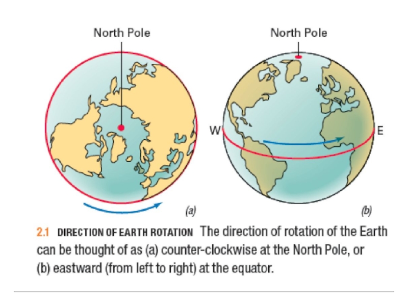
Слайд 3Earth Rotation
Earth rotation refers to the counter-clockwise turning of the Earth
on its axis (imaginary line passing through the centre of the planet and joining the north and south poles).
Environmental Effects of Earth Rotation
The Earth’s rotation causes the coriolis effect (winds and ocean currents are deflected to the right of their path in the northern hemisphere; left in the southern hemisphere).
Environmental Effects of Earth Rotation
The Earth’s rotation causes the coriolis effect (winds and ocean currents are deflected to the right of their path in the northern hemisphere; left in the southern hemisphere).

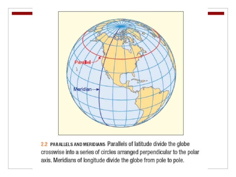
Слайд 5The Geographic Grid
Parallels and Meridians
The geographic grid is a spherical coordinate
system (set of circles called parallels and meridians) used to determine the locations of features on the Earth’s surface.

Слайд 6The Geographic Grid
Parallels are a set of circles arranged perpendicular to
the axis of rotation (equator, midway between the north and south poles is the longest parallel).
Meridians are a set of circles at right angles to the parallels.
Meridians are a set of circles at right angles to the parallels.

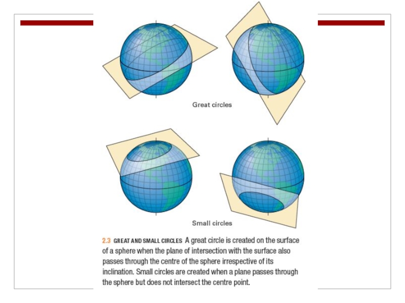
Слайд 8The Geographic Grid
Great circles are constructed so that the plane of
intersection with the surface of the sphere passes through the centre of the globe.
With small circles the plane of the intersection passes through the surface of the sphere , but not its centre.
With small circles the plane of the intersection passes through the surface of the sphere , but not its centre.

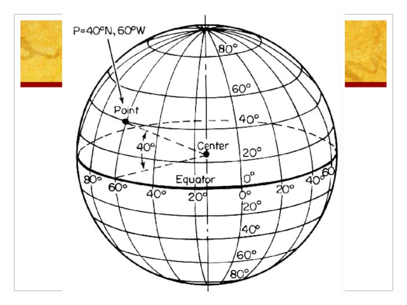
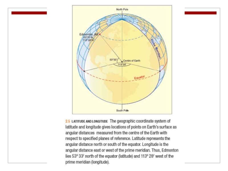
Слайд 10The Geographic Grid
Latitude and Longitude
The equator is the only great circle
parallel and is given the value of 0º.
Parallels of latitude measure the angular distance north and south of the equator.
In the northern hemisphere, latitude ranges from 0º to 90º N at the North Pole; in the southern hemisphere, latitude increases to 90º S at the South Pole.
Parallels of latitude measure the angular distance north and south of the equator.
In the northern hemisphere, latitude ranges from 0º to 90º N at the North Pole; in the southern hemisphere, latitude increases to 90º S at the South Pole.

Слайд 12The Geographic Grid
By international convention the meridian running through the Royal
Observatory in Greenwich, England, is used as the prime meridian of the world (commonly the Greenwich meridian; 0º longitude).
Meridians of longitude measure angular distance east and west of the prime meridian (range: from 0º to 180º E or 180º W).
Meridians of longitude measure angular distance east and west of the prime meridian (range: from 0º to 180º E or 180º W).

Слайд 13The Geographic Grid
For greater precision, degrees of latitude and longitude can
be subdivided into minutes (1/60 of a degree) and seconds (1/60 of a minute).

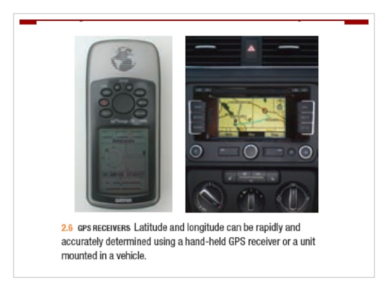
Слайд 15The Geographic Grid
A Global Positioning System (GPS; 24 satellites at an
altitude of 20,200 km) can provide location (latitude and longitude) information to an accuracy of about 10m horizontally and 15 m vertically.
")
Слайд 17Map Projections
Because the Earth’s shape is nearly spherical, it is impossible
to represent it on a flat sheet of paper without distorting the curved surface in some way.
There are various ways to mathematically change the actual geographic grid of curved parallels and meridians into a flat coordinate system (Map Projections).
There are various ways to mathematically change the actual geographic grid of curved parallels and meridians into a flat coordinate system (Map Projections).

Слайд 18Map Projections
The polar projection can be centred on either the North
or South Pole.
The Mercator projection is a rectangular grid with meridians shown as straight vertical lines, and parallels as straight horizontal lines.
The Goode projection uses two sets of mathematical curves to form its meridians. It uses sine curves between the 40th parallels, and beyond the 40th parallels, towards the poles, it uses ellipses.


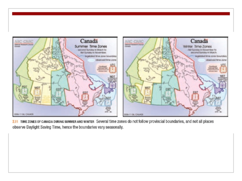
Слайд 22Global Time
Global time systems, like map projections, are also derived from
the geographic grid, but with the additional component of Earth’s rotation.
Standard Time
In the standard time system, the Earth is divided into 24 time zones.
Standard Time
In the standard time system, the Earth is divided into 24 time zones.

Слайд 23Global Time
World Time Zones
Identified according to the number of hours
each time zone differs from the time in Greenwich, England (ex. -7 indicates that local time is seven hours behind Greenwich time, +2 indicates that local time is two hours ahead or Greenwich time).

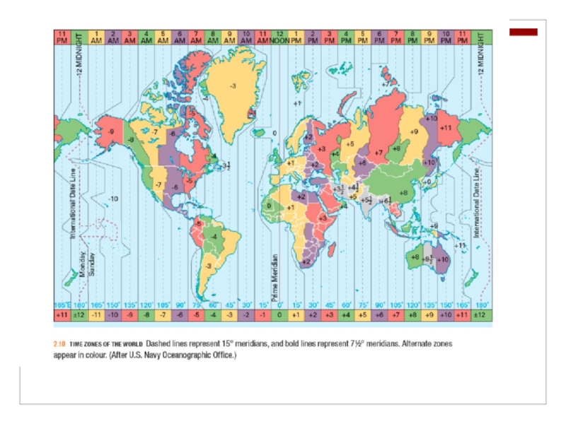
Слайд 25Global Time
Because of the historical importance of the Greenwich Observatory, world
time was traditionally referenced to Greenwich Mean Time (GMT) – recently replaced by Coordinated Universal Time (UTC).

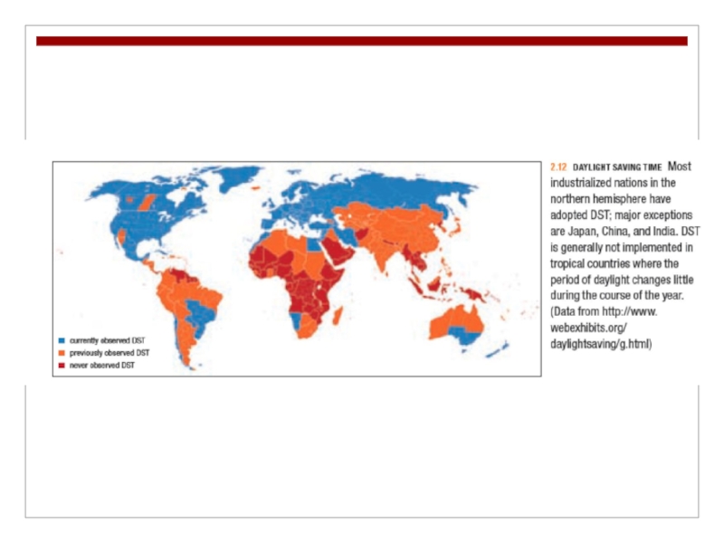
Слайд 26Global Time
Daylight Savings Time (DST)
Established by setting all clocks ahead
by one hour in the spring to transfer the early morning daylight period to the early evening.
 Established by setting all clocks ahead by one hour in")
Слайд 29Global Time
International Date Line
The 180th meridian serves as the International Date
Line; calendars advance by one day when travelling westward across the date line and turn back by one day when travelling eastward across the date line.

Слайд 30The Earth’s Revolution Around the Sun
The orbital motion of the Earth
around the sun is termed revolution.
It takes 365.242 days for the Earth to complete one revolution (orbit) around the sun.
It takes 365.242 days for the Earth to complete one revolution (orbit) around the sun.

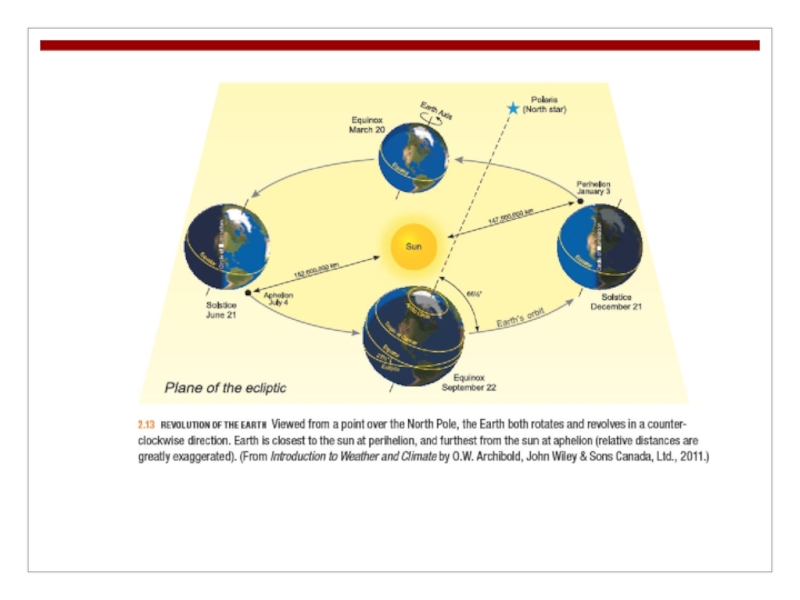
Слайд 32The Earth’s Revolution Around the Sun
Because the Earth traces a slightly
elliptical orbit around the sun, the distance between them varies by about 3 percent during each revolution.
Perihelion: when the Earth is nearest the sun (Jan. 3; 147.7 million km).
Aphelion: when the Earth is furthest from the sun (July 4; 152.6 million km).
Perihelion: when the Earth is nearest the sun (Jan. 3; 147.7 million km).
Aphelion: when the Earth is furthest from the sun (July 4; 152.6 million km).

Слайд 33The Earth’s Revolution Around the Sun
Tilt of the Earth’s Axis
The Earth’s
axis is tilted with respect to the plane of the ecliptic (the plane circumscribed by the Earth’s orbit around the sun) by 66.5º.

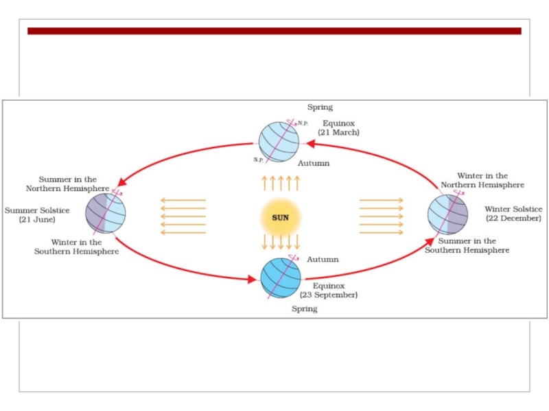
Слайд 36The Earth’s Revolution Around the Sun
Solstice and Equinox
On or about
December 22, the Earth is positioned so that the North Pole is inclined at an angle of 23½º away from the sun, and the South Pole is inclined at the same angle toward the sun (winter or December solstice).
Six months later, on or about June 21, the Earth is at the opposite point in its orbit (summer or June solstice).
Six months later, on or about June 21, the Earth is at the opposite point in its orbit (summer or June solstice).

Слайд 37The Earth’s Revolution Around the Sun
The equinoxes occur midway between the
date of the solstices, and at these times the Earth’s axial tilt is neither toward nor away from the sun.
The vernal equinox (spring equinox) occurs on or about March 21 and the autumnal equinox (fall equinox) on or about September 22.
The vernal equinox (spring equinox) occurs on or about March 21 and the autumnal equinox (fall equinox) on or about September 22.

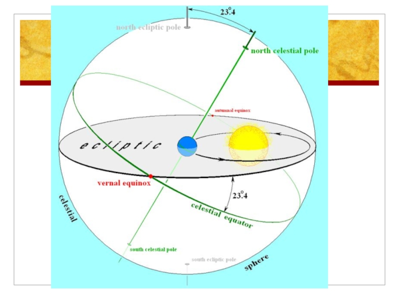
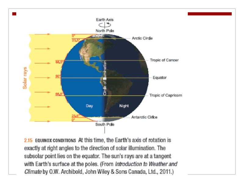
Слайд 38The Earth’s Revolution Around the Sun
Equinox Conditions
At the equinoxes the circle
of illumination passes through the North and South Poles.
The subsolar point, the point on the Earth’s surface where the sun at noon is directly overhead, falls on the equator.
The subsolar point, the point on the Earth’s surface where the sun at noon is directly overhead, falls on the equator.

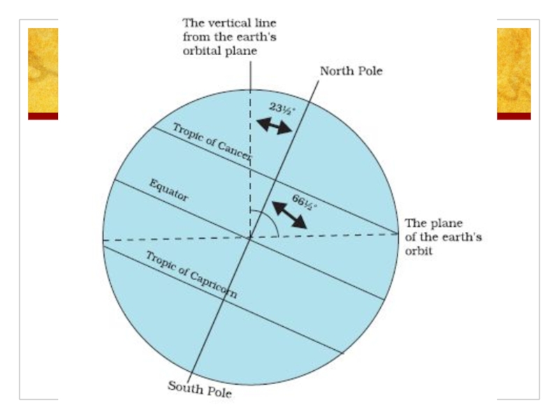
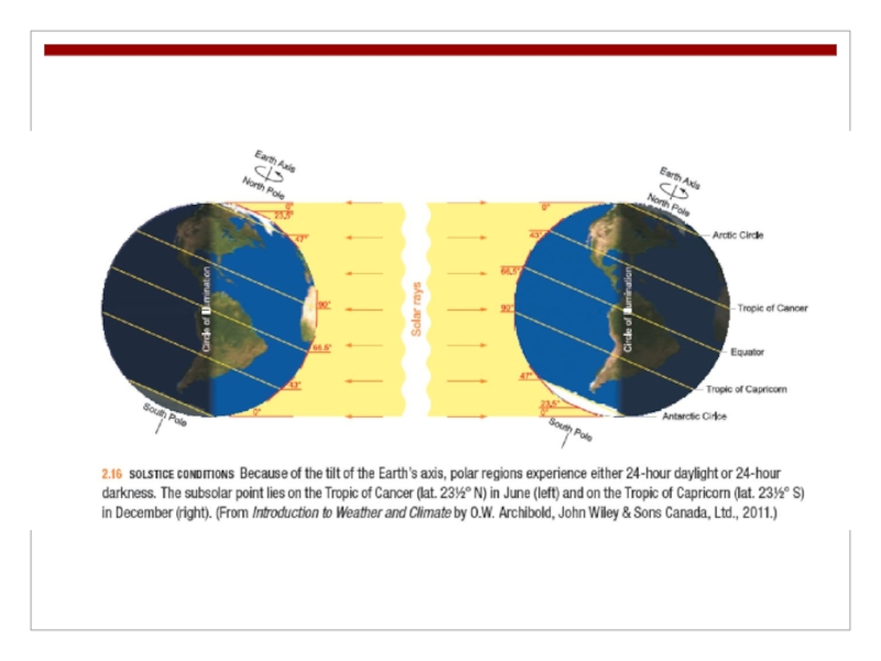
Слайд 40The Earth’s Revolution Around the Sun
Solstice Conditions
During both the June and
December solstices the circle of illumination passes from the Arctic Circle (parallel at 66½º N) to the Antarctic Circle (parallel at 66½º S).
June Solstice: the subsolar point is 23½º N (parallel known as the Tropic of Cancer).
December Solstice: the subsolar point is 23½º S (parallel known as the Tropic of Capricorn).
June Solstice: the subsolar point is 23½º N (parallel known as the Tropic of Cancer).
December Solstice: the subsolar point is 23½º S (parallel known as the Tropic of Capricorn).

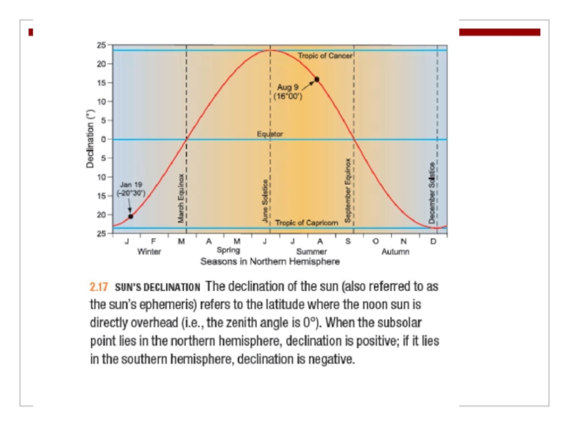
Слайд 43The Earth’s Revolution Around the Sun
The subsolar point travels northward and
southward in its annual cycle between the Tropics of Cancer and Capricorn.
The latitude of the subsolar point is referred to as the sun’s declination.
The latitude of the subsolar point is referred to as the sun’s declination.

Слайд 45The Earth’s Revolution Around the Sun
The difference in duration of daylight
and darkness increases with latitude.