- Главная
- Разное
- Дизайн
- Бизнес и предпринимательство
- Аналитика
- Образование
- Развлечения
- Красота и здоровье
- Финансы
- Государство
- Путешествия
- Спорт
- Недвижимость
- Армия
- Графика
- Культурология
- Еда и кулинария
- Лингвистика
- Английский язык
- Астрономия
- Алгебра
- Биология
- География
- Детские презентации
- Информатика
- История
- Литература
- Маркетинг
- Математика
- Медицина
- Менеджмент
- Музыка
- МХК
- Немецкий язык
- ОБЖ
- Обществознание
- Окружающий мир
- Педагогика
- Русский язык
- Технология
- Физика
- Философия
- Химия
- Шаблоны, картинки для презентаций
- Экология
- Экономика
- Юриспруденция
Sights of kyrgyzstan презентация
Содержание
- 1. Sights of kyrgyzstan
- 2. Lake of Sary-Chelek.alt Alpine lake of
- 3. he main objects of these forests are
- 5. ash-Rabat. The ancient mystery.alt More than
- 6. In the inside the building fully confirms
- 8. on-Kul. The fairy tale of highlands. Son-Kul
- 9. According to this legend, in this place,
- 10. The Issyk-Kul lake is nonfreezing mountain miracle
- 11. The Legend of Issuk-Kul Lake According to
- 12. Inylchek glacier E-mail Print PDF
- 13. 250 million cubic meters of water with
- 14. Arslanbob The tract of Arslanbob. The tract
- 15. According to another beautiful local legend, Alexander
- 16. The and

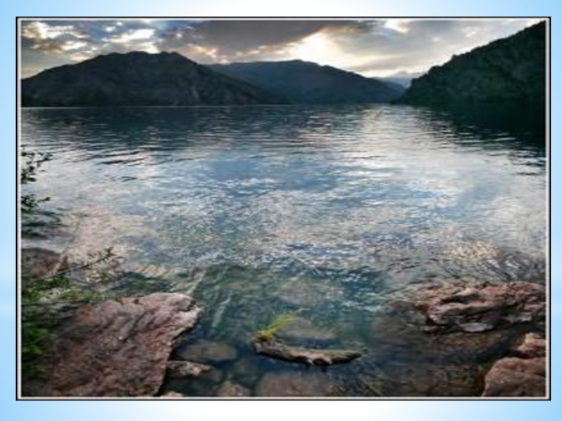
Слайд 2Lake of Sary-Chelek.alt Alpine lake of Sary-Chelek, is considered to be the
most beautiful place in the west of Kyrgyzstan. It lies at an altitude of 1940 meters above sea level in the foothills of the Chatkal range, 500 kilometers from the capital city of Bishkek and 300 ki meters from the city of Osh.
The lake’s extension from the south-west to north-east is 7.5 kilometers, water surface area is 50.7 square kilometers and a depth in some places reaches 234 meters. It was formed as a result of the earthquake that occurred many centuries ago, when on an incredible scale landslide blocked one of the Kara-Suu - Kojo-Ata river tributary, and the river flooded the whole valley.
By the way, by the depth Sary-Chelek is the third in Central Asia and the second in Kyrgyzstan.
Due to the great depth, water temperature, even in summer does not exceed 18 C and in winter it is at around 4 C-0C. The lake is a freshwater river and gives a start to the Kojo-Ata.
The northern coast of Sary-Chelek is almost completely overgrown with spruce and fir forests. Thus, their density is such deep that, even in the sunniest day it is always half-dark and cool. The air of that place is filled with the smell of pine needles and flowering herbs. Nepuganaya marinka(species of trout) swims in creeks and all the hills are overgrown by raspberries and blackberries – that is a real paradise on earth.
Of course, somebody might think this way, but only in case he has not visited the south bank of the Sary-Chelek.
Here, from the southern shore, the lands belonged to the Sary Chelek Biosphere Reserve start. The territory covered by it is relatively small – at about 23 900 hectares.
It occupies a small mountain valley of Arkyt basin with elevation of altitudes from 1200 to 4247 meters. It was created in order to save the walnut-fruit lands, as well as alpine landscapes, with their endemic flora and fauna.
A landscape here is really of a remarkable beauty. The grasslands and steppes of foothills, wild rivers and pristine lakes make a lasting impression, but the main wealth of the Preserve –used to be walnut-fruit forests - a unique phenomenon, which almost anywhere in the world can not be found in this volume.

Слайд 3he main objects of these forests are the walnut trees, apples
and pears.
Fauna of the Reserve is diverse and colorful. Here, under the vigilant protection of human bears, martens, porcupines, leopards, lynx, deer, argali, wild boar, as well as 157 species of birds freely live.
Dozens of mountain creek happily flock to the lake, almost vertical cliffs, steeply down to unprecedented depths. The azure of the water reflects the traveling clouds so that it does not clear whether they are floating in the sky, or on the water. Coastal gray rocky hills, covered with pine and walnut-fruit forests, bring the effect the patina into landscape and the lake seems to be a precious sapphire in a setting of old greenish silver.
The name of the lake, literally translated as "yellow barrel", there is even the option of "yellow bucket." All this is justified with respect to the shape of the reservoir, which, with a stretch, really looks like a deep vessel. However, of the yellow color it can be only in the autumn, when the surrounding woods are dressed into such a sunny color, and reflected in the clear water make it a happy yellow - the color of freshly honey sloshing in a bucket of a hospitable bee-keeper.
Like every self-respecting tourist attraction, Sarah Chelek, for many centuries, overgrew with many beautiful legends and myths. But I would like to tell you a "fairy tale", which took place just recently...
In May 1936, a scientific expedition arrived at the lake of Sary-Chelek, it was sparse and consisted of only 4 people. One evening, when it was getting dark, all team members were sitting around the campfire, drinking tea and had an unhurried conversation about local enigmatic beauty. Suddenly the figure of an old bent man came from the darkness into the circle of light, who leaned on a wooden, polished over the years staff. How and which part the old man approached, no one noticed, but according to the laws of hospitality he was immediately given space closer to the fire and was presented a bowl of fragrant drink.

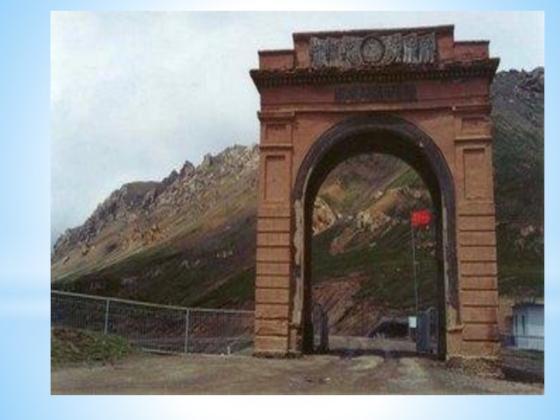
Слайд 5ash-Rabat. The ancient mystery.alt
More than 100 kilometers from the city of
Naryn hidden in the distant valley of Kara-Kayun, at an altitude of 3600 meters above sea level, near the border with China, there is hiding quite unusual and therefore very mysterious monument of medieval architecture in Kyrgyzstan - Tash-Rabad.
Historians and archaeologists are still arguing who, when, and most importantly, why built this unusual structure of solid stone, in such a sparsely populated area.
Some scientists believe that Tash-Rabat was used as caravanserai of the late middle Ages, while others tend to believe that this structure represents the ruins of the monastery of Christian Nestorians. Both of these versions have a right to exist, because in the Middle Ages, merchants and the wandering monks were using the same paths, often side by side.
There were the houses of reception of guests - caravan-sheds, and religious buildings, monasteries and temples at all crossroads of the Silk Road were built.
Along with the significant differences of structures, they very often had common features, both architectural and functional. After all, it is no secret that in common the monasteries have never denied the sales people in lodging, and still the pilgrims monks were often met in the caravanserai with warmth.
Anyway, let us try not to understand the subtleties of the case of archaeologists, and we would better take a look at this phenomenon more closely.
Tash-Rabat’s presumed dates of building are X-XIIcenturies, it is almost square building with sides of length 35.7 and 33.7 meters, covered by a low spherical dome. The main facade of the structure, traditionally located on the east side and a high stone wall, which are located in the center of the high iron gates of the portal and the arch, and laterally symmetrical towers. The building was built just below the mountain, and it seems that the back yard has an extension in height.

Слайд 6In the inside the building fully confirms its venerable age. On
architectural traditions of the Middle Ages from the gate to the central hall there is spacious enough Corridor Gallery, on the sides of which there were located side rooms, at the same time the floor in them is lower than in the gallery. In the most areas there are no windows, so here is always a shadow in them, only the central hall is a little illuminated, in which light penetrates from the small holes around the circumference of the dome. And in this scattered light the remains of murals bearing floral design, which once covered the dome from the inside can be seen.
If we add to all the above, the fact that the building was fully built out of solid rock, it is believed that you will gat the impression.
On the hillside and around the buildings there is a necropolis, which is visible on the surface of earth mounds and some stone slabs. Perhaps there the people were continued to be buried even after the building was abandoned.
There were a lot of rumors and legends about who was actually built Tash Rabat. By one of them, the ancient builders were righteous - a father and son who survived the flood here, which was sent down to the land for the sins of people. It was exactly the building of the church which saved them from imminent death, but the man is weak, and the temple was never completed.
Once during one of the days of cutting off the roof of the sanctuary the son saw in the distance passing caravan and asked his father to go to althear the news. The father let his son, though he did not come back, he had gone with the caravan, in which, according to the legend, rode a beautiful girl. The old man was helped by the passing pilgrims to finish building the temple, carrying heavy stones on the roof of the building.

Слайд 8on-Kul. The fairy tale of highlands.
Son-Kul or rather Son-Kel - is
a fabulous high mountain lake, situated at ease in a natural basin, outspread between two spurs of the Tien-Shan - Son-Kul-Too and Moldo-Too. Located at an altitude of 3016 meters above sea level in north-western part of the Naryn region of Kyrgyzstan, it is an excellent eco-tourism facility.
Son-Kul - is the second largest and the first in fresh water natural lake in the country. This lake spread over 28 kilometers in length and 18 kilometers in wide, its water surface area is 278 square kilometers, and the greatest depth reaches 22 meters.
Lake fed by many streams and mountain Sai (creeks), rushing here from the surrounding mountains, and flows out of them only one river - Son-Kul, which later merges with rough waters of Naryn.
The lake has a tectonic origin and was formed, most likely as a result of the earthquake, but the beauty of these places can not believe in such prose of life. Therefore, local people have their own interpretation of the origin of their favorite lake.
According to this legend, in this place, once upon a time there was the castle of the cruel Khan. The governor was not yet old and loved to fill his harem. Especially for this purpose he sent messengers to all parts of the Tien Shan, and the rare beauty was able to go unnoticed.
Being locked away from the world and suffering from the despotism of the ruler, the girls began to complain and offer prayers to release them from their evil fate.

Слайд 9According to this legend, in this place, once upon a time
there was the castle of the cruel Khan. The governor was not yet old and loved to fill his harem. Especially for this purpose he sent messengers to all parts of the Tien Shan, and the rare beauty was able to go unnoticed.
Being locked away from the world and suffering from the despotism of the ruler, the girls began to complain and offer prayers to release them from their evil fate.
The mountains heard their cries and then disaster happened. Literally overnight the castle of the hated Khan fell to the bottom of the ravine and water gushed from the peaks. Water was so much, it was so cold and it was all coming again and again until it flooded the low ground and the surrounding area. They say that this was a huge glacier, which was situated almost in the heavens, mourned the death of beautiful women. Storm raged for several days, and when everything calmed down, before the eyes of astonished people presented itself a beautiful lake with crystal-clear and very cold water, which since is called as Son-Kul.
Indeed, the water in the lake is very cold. The average annual temperature of it is around - 3.5 C. In summer in the shallow water of course can be warmed up to 11C +, but in winter, the temperature rarely rises above-20C. Thus, from September to July, the lake is tightly constrained with a sturdy shell of ice.
The spectacle is magnificent, but only few tourists can admire this brilliant panorama. Coastal neighborhood inundated with snow, the minimum height of which is 1.5 meters, and mountain passes, through which you can get here, are closed because of avalanche danger.
However, in the summer this is another story.
In the warm season a truly pleases the soul picture can be presented to the gaze of curious tourists. There are not here tall trees or furry bush thickets, but the variety of herbs and flowers can touch the imagination of even the most experienced artist.

Слайд 10The Issyk-Kul lake is nonfreezing mountain miracle of tectonic origin located
in the deep intermountain hollow between Kungey Ala-Too spurs and Terskey-Ala-Too ridge on the 1609 m altitude above the sea level. Mountain ridges protect the lake from cold air from the north and from hot breath of desert from the south. Therefore the local climate is warm and soft – here exhausting heat and strong frosts don’t happen.
Issyk Kul is one of the biggest and most beautiful high-mountain lakes of the world (it has 170 km length and 70 km width, being the second-largest mountain lake in the world after Titicaca – lake in South America). Depths in lake are not everywhere identical (the greatest depth is 700 m) hence the water everywhere gets warm differently.
Issyk Kul is one of the biggest and most beautiful high-mountain lakes of the world (it has 170 km length and 70 km width, being the second-largest mountain lake in the world after Titicaca – lake in South America). Depths in lake are not everywhere identical (the greatest depth is 700 m) hence the water everywhere gets warm differently.

Слайд 11The Legend of Issuk-Kul Lake
According to one legend, the appearance of
this beautiful lake is connected with a beautiful girl who sacrificed their lives for their beloved. "In ancient times there was an old city. The town is on top of a steep hill stood the castle. Belonged he old and powerful Khan, who was famous not only for its wealth, but even with their brutality. Not a day passed that someone did not become a victim his whim. Despite old age, Khan was lust, but he did not know either love or affection. One day the news reached him that a poor family of nomads is a fabulous girl, and he decided to take her. This girl lived in a small village, nestling in the foothills on the banks of the creek. No one glorious brave in battle laid his head for a beautiful woman, but the proposals of marriage, it all replied that she loves another.
I loved a girl, no one could know, and she herself did not know. I only remember that in one early morning when the sun lit up the mountain peaks, appeared before her on a white horse, the handsome brave, sat her on his horse, and together they soared higher and higher. Remember, as with the swiftness of the vortex, they flew together in the inaccessible heights as he hugged her, kissed, and parted, took off his ring and put on her finger, said: "I'll be back soon. The ring will never take off until it is yours, no calamity will not touch you. "
And now, when the envoys Khan came to her with rich gifts and offered to marry him, she indignantly repelled gifts and said:
- I love the other, and draw his wife, except for her beloved, I will not!
Having said this, she quietly went into the mountains, hoping to meet again brave rider to seek his protection.
And only then she noticed that the ring has disappeared with her hands, she burst into tears and decided to return home. Before she could reach home, as it was surrounded by armed horsemen, and caught and quickly disappeared into the gloomy gorge. When she was released and took off the bandage from her eyes, she found herself among the fairy-tale splendor. Then she realized that she is a prisoner of the khan, and decided to die rather than become his wife.
Khan fought against it, unheard of luxuries, but no gifts could not shake her. Finally, Khan decided to take by force what fruitlessly sought gifts. He again came to her, promising for the love of everything, even freedom.
- I love another - was the old answer.
Khan threw himself on the girl, but she quickly found the open window, over the yawning abyss.
- No, Khan, I'll be your - and with a loud cry she threw herself down. At the same moment wavered impregnable wall collapsed granite vaults, fell dark castle of the old khan, and of all the gorges gushing water, has already disappeared under the water, the remains of the Khan's palace and the water was coming and everything was coming up until no more flooded the valley. "

Слайд 12 Inylchek glacier
E-mail Print PDF
Inylchek - natural and ecological complex
of highlands.
Actually, the nature has such landscapes which that can not be precisely defined. Thus, the majestic mountain site of Muzdag - "Ice Mountain" is a clear confirmation of it. It is located in the most extreme and highest point of the Central Tien Shan, near the borders with Kazakhstan and China. Its territory includs a huge area of mountain ranges of incredible beauty, the most popular of which are the Peak of Pobeda and Khan Tengri – both of 7000 meters, and alpine glacier, named Inylchek and the highland Lake of Merzbacher.alt
Grand view opens from a helicopter on approach to "Ice Mountain", everywhere you look down the white realm of eternal ice stretches, and mountain ridges, just like the teeth of predatory sharks, ripe blue skies. A look at once distinguishes two main peaks of Muzdaga - Pobeda Peak and Khan-Tengri, which like brothers are situated opposite each other...
f you look, the peak of Pobeda is not the mountain, and certainly not rock, it is a huge mountainous area. It takes the start at the junction of the highest Tien Shan ridges - Kokshal-Too and the Meridian, in the place of the connection the height reaches 7003 meters - that is the eastern point of Pobeda Peak. From this place, the crest goes to the west, some going down, then shoots up rapidly, forming the peak of Soviet Armenia, and after a short descent goes to the highest point of the ridge.

Слайд 13250 million cubic meters of water with the noise and roar
for a few days pour out from the mouth of the lake and 15 kilometers below the "dam" digging out, forming an uncontrollable flow that fills the valley of Inylchek river. Discharge of water takes the character of the catastrophic floods, with irresistible force the rushing rapids along the river bed, during a few hours to overcome a distance of 50 kilometers, and flows into no less raging torrent of the Saryzhas river. Only in the territory of China water weakens a little, becoming one of the components of the Great Yellow River, and after that almost deliberately carries its waters to the ocean.
Generally speaking, in relief of melt water by alpine ponds is not surprising, but in the case of Lake Merzbacher, all the natural mechanisms that trigger this process are turned upside down, and scientists still have not found the answers to obvious questions.
Generally speaking, in relief of melt water by alpine ponds is not surprising, but in the case of Lake Merzbacher, all the natural mechanisms that trigger this process are turned upside down, and scientists still have not found the answers to obvious questions.

Слайд 14Arslanbob
The tract of Arslanbob.
The tract of Arslanbob is one of the
most unique creations of nature, gorgeously blooming oasis, which is situated between mountains of the western and southern slopes of the Fergana and Chatkal ranges of the central Tien Shan. Here, at the height of more than1600 meters above sea level, in the rarest climatic conditions of neighboring air masses excellent nut forests expanded, the total area of which is 700.000 hectares.
Forest age, according to scientists’ researches can exceed 50 million years and their origin is likely to refer back to the Paleolithic period. One of the largest arrays of the forest is located along the rocky cliffs of the Babash-Ata ridge, which skirts as a natural barrier the village of Arslanbob - one of the most famous "holy" places in the Central Asia.
Forest age, according to scientists’ researches can exceed 50 million years and their origin is likely to refer back to the Paleolithic period. One of the largest arrays of the forest is located along the rocky cliffs of the Babash-Ata ridge, which skirts as a natural barrier the village of Arslanbob - one of the most famous "holy" places in the Central Asia.

Слайд 15According to another beautiful local legend, Alexander of Macedon during his
campaign to Sogdiana, went through these sites. Literally "close" in the area of modern Khujand he constructed a fortress - Alexandria (one of the latest). The scouts, who were sent to find the way to India brought from the mountains large supplies of walnut and the news that thanks to this wonderful fruit they have recovered from an unknown illness that cruelly tormented almost the entire army during month.
Scientists tend to assume this disease to be the deficit of iodine. Although, I think, everything was much simpler.
Surely, everyone knows "chronic disease" of tourists due to the change of water and diet - banal diarrhea. Thus, skin and kernel of walnut are sufficiently contain iodine and tannins, which are considered to be great help from this "unaesthetic” disease. And of course, prudent Alexander, for sure, stocked up on this wonderful medicine, and brought it, such a way, home.
But the forests of walnut are not the only attraction of this place. Air, nature and mountain landscapes are real treasures of this land.
The tract extends over 10 kilometers along the bustling mining river, on the banks of which there are numerous recreational areas and resorts.
The picturesque alpine meadows spread out around, amazing with a riot of colors, the waterfalls of rare beauty welcome with their coolness on a hot summer day, the mountain caves promise to share the centuries-old secrets, blue lakes, having crystal clear water invite guests to the shelter of coastal trees and talkative mountain streams rush to share the latest news. And over all this splendor, as a mute giant stands peak of Babash-Ata (4490 meters), covered with a cap of no melting snow.