- Главная
- Разное
- Дизайн
- Бизнес и предпринимательство
- Аналитика
- Образование
- Развлечения
- Красота и здоровье
- Финансы
- Государство
- Путешествия
- Спорт
- Недвижимость
- Армия
- Графика
- Культурология
- Еда и кулинария
- Лингвистика
- Английский язык
- Астрономия
- Алгебра
- Биология
- География
- Детские презентации
- Информатика
- История
- Литература
- Маркетинг
- Математика
- Медицина
- Менеджмент
- Музыка
- МХК
- Немецкий язык
- ОБЖ
- Обществознание
- Окружающий мир
- Педагогика
- Русский язык
- Технология
- Физика
- Философия
- Химия
- Шаблоны, картинки для презентаций
- Экология
- Экономика
- Юриспруденция
SMCP. The Standard Marine Communication Phrases презентация
Содержание
- 1. SMCP. The Standard Marine Communication Phrases
- 3. CONTENTS ON PAGES: 4 - 15:
- 4. s Port of Rotterdam. 4 General
- 5. Alfa Charlie Golf Bravo
- 6. Numbers must be spoken in separate digits
- 7. Use the following message markers as often
- 8. Always answer
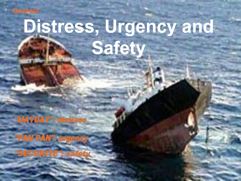
- 9. "MAYDAY": distress "PAN PAN": urgency
- 10. I read you bad / signal strength
- 11. “Mistake ….. correction” is used when
- 12. example “Repeat” (or “I say again”) is
- 13. “Say again” is used when a message
- 14. Position:
- 15. “Bearing” (when the vessel’s position is
- 16. 16 Distress “Mayday”
- 17. Location of the fire: . The
- 18. Location of the fire: . Fire
- 19. . Vessel is unmanoeuvrable. . Fire cannot
- 20. Water is entering the vessel below the
- 21. . Vessel is heeling over to
- 22. . Vessel is unable to continue her
- 23. 23 . Vessel is unable to manoeuvre
- 24. . We have had a collision with
- 25. . Vessel is damaged
- 26. . Vessel is aground in
- 27. . Refloating expected when tide
- 28. . Vessel is losing dangerous substance
- 29. 29 . No damage has been
- 30. Piracy. 30 . Six crew members have
- 31. 31 . Vessel will continue her voyage.
- 32. Search And Rescue-Unit is underway to
- 33. SRU will be the on-scene co-ordinator. Information:
- 34. . Vessel requests for helicopter with doctor.
- 35. . Weather in distress position:
- 36. Message from RCC: helicopter is airborne
- 37. . Information for helicopter pilot: relative
- 38. 38 . Someone has fallen overboard in
- 39. . Request to all vessels to assist
- 40. . The search for the missing person
- 41. 41 “pan pan” Urgency
- 42. . Vessel is unmanoeuvrable due to problems
- 43. . Other traffic must keep a
- 44. Vessel has problems with her manoeuvrability. Other
- 45. . There is a vessel manoeuvring with
- 46. Ice. 46 . Vessel has problems with
- 47. 47 “SECURITE” Safety
- 48. Gale warning: wind direction NW
- 49. 49 . Swell of 3 metres from
- 50. . We expect a freak wave by
- 51. . Depth as indicated in chart must
- 52. . Abnormally low water is expected within
- 53. . The tide is 2 metres higher
- 54. . We have a visibility of
- 55. . We have reduced visibility due
- 56. . Ice warning: an iceberg has
- 57. . We expect that the ice situation
- 58. Ice. . Ice-breaker assistance cancelled and
- 59. NAVWNG Navigational Warnings. . We have
- 60. . We have detected an
- 61. Navigational Warnings. NAVWNG . A shoal
- 62. Navigational Warnings. . We are performing dangerous
- 63. 63 Safety Lights
- 64. Navigational Warnings - lights. No light on
- 65. AP2-buoy in posn…. is unreliable. Buoy Alfa
- 66. FL1-buoy in posn…. is missing. 66
- 67. 67 . Leading light on pierhead temporarily
- 68. 68 Pilotage
- 69. . Vessel requires pilotage in posn …...
- 70. . Vessel does not require pilotage
- 71. . VTS indicates to vessel that
- 72. . Distance between vessel and pilot station
- 73. 73 . Time of arrival at pilot
- 74. 74 . VTS indicates to vessel
- 75. 75 . VTS indicates to vessel that
- 76. . VTS indicates to vessel that
- 77. 77 . VTS indicates to vessel that
- 78. . Pilot boat is approaching. 78
- 79. . Pilot will come on board at
- 80. . Vessel must make lee on sb-side
- 81. . Vessel must keep a heaving line
- 82. . Boarding speed: 6 knots. 82 You
- 83. 83 . It is not possible for
- 84. s 84 Vessel Traffic Service Information
- 85. VTS-operators must avoid the use of the
- 86. 86 Vessel Traffic Service Tidal Information
- 87. . Tide is getting low. .
- 88. . Rate of tidal stream is
- 89. . Rate of the current is 1.4
- 90. 90 Vessel Traffic Service Ship movement and traffic information
- 91. . MV Christina is in the entrance
- 92. Vessel is crossing the fairway on course
- 93. . There are salvage operations in
- 94. . Cable Layer Aurora in posn. 6.5
- 95. . Route from roadstead to entrance temporarily
- 96. 96 39 degr. 16 min. N / 027 degr. 15 min.W. Position
- 97. Bearing 158 degr. from the Bassurelle,
- 98. Coastal Station has located your vessel
- 99. Answer from vessel Alfa: Seaborne DKEL;
- 100. ALFA
- 101. Information from
- 102. Information from
- 103. s 103 Course
- 104. Track: . parallel with the reference line.
- 105. The course that the vessel is steering
- 106. Danger! . waters to the N are
- 107. . Vessel is going to collide with
- 108. . Danger! Navy practising in
- 109. 109 Arrival s
- 110. . Vessel is allowed to enter traffic-lane
- 111. . Vessel’s berth is not ready yet.
- 112. 112 . Vessel is advised to drop
- 113. . Anchoring is forbidden outside the roadstead
- 114. .Vessel is impeding (hindering) other traffic.
- 115. 115 You have permission
- 116. . Vessel is forbidden to dredge her
- 117. . Vessel in posn…… is
- 118. . Vessel has to heave up her
- 119. . Vessel is not in the correct
- 120. s 120 Canal, lock and convoy operations The Suez Canal
- 121. . Vessel has to wait for
- 122. . Vessel has to move closer to
- 123. MV Seaborne - DKEL, in posn.
- 124. 124 Intership Communication s
- 125. Vessel’s intention is : . to
- 126. . to change course to port,
- 127. . to increase speed to 9 knots.
- 128. . to continue her voyage and enter
- 129. 129 . to pass the vessel that
- 130. . to pass Pulau Karimum-light at 16.50
- 131. . to go to an anchorage. Intention:
- 132. Vessel warns other vessel : . danger!
- 133. . danger! Shoals ahead. Warning: you are
- 134. . danger! There is an underwater-wreck ahead.
- 135. Vessel warns other vessel : . danger!
- 136. 136 Intraship Communication s
- 137. . We are going to drop sb
- 138. . Cable is leading astern; anchor is
- 139. . We are going to heave anchor.
- 140. . There are 3 shackles left to
- 141. . We are going to berth on
- 142. . Keep tension on the springs. Keep
- 143. . Prepare to start engines. Stand by
- 144. . Prepare to cast off! Stand by for letting go! 144 Casting off Intraship Communication
- 145. . Let go all but the
- 146. . Cast off the head line:
- 147. Finished with manoeuvring station! . Finished casting off. 134 147 Casting off Intraship Communication
- 148. . Rudder must be held in the
- 149. OOW Helmsman gives helm order: steer 182
- 150. . Engine power: very slow ahead. .
- 151. mu

Слайд 2
2
This
the Standard Marine Communication Phrases - Part A
that must be used in VHF-communication by radio-operators
on board vessels and at radio stations.
In this presentation no standard procedures are applied
(e.g. announcing and acknowledging, using the word “over”,
“address and identify”, etc.).
For procedures on VHF-Communication please refer to the presentation about this subject.
Click to open the entire SMCP (Microsoft-Word doc.)
SMCP

Слайд 3CONTENTS ON PAGES:
4 - 15: General.
16 - 40:
Fire;
Flooding;
List;
Disabled and adrift;
Collision;
Grounding;
Piracy;
SAR;
Person Over Board;
41 - 46: Urgency:
Manoeuvrability;
Cargo (spilling);
Ice;
47 - 67: Safety:
Wind;
Sea State;
Tides;
Visibility;
Ice;
Navwng;
Lights;
68 - 83: Pilotage.
84 - 123: Vessel Traffic Service:
Position and direction;
Tidal Information;
Traffic Image;
Position;
Course;
Arrival;
Anchoring;
Canal, locks and convoy;
Handing over;
124 - 135: Intership communication;
136 - 150: Intra-ship communication:
Anchoring;
Berthing;
Casting off;
Helm orders;
Engine room orders.
3


Слайд 5Alfa
Charlie
Golf
Bravo
Delta
Echo
Foxtrot
Hotel
India
Juliet
Kilo
Lima
Mike
A -
B -
C -
D -
E -
F -
G -
H -
I -
J -
K -
L -
M -
When spelling is necessary, only the following spelling table should be used:
November
Papa
Tango
Oscar
Quebec
Romeo
Sierra
Uniform
Victor
Whisky
X-ray
Yankee
Zulu
N -
O -
P -
Q -
R -
S -
T -
U -
V -
W -
X -
Y -
Z -
5
Alphabet
General

Слайд 6Numbers must be spoken in separate digits ……,
……, unless they
“My position is:
29 degrees 58 minutes North / 013 degrees 12 minutes East
at 2100 hrs. UTC”.
“Starboard 15”.
6
“My position:
bearing 168 degrees from Royal Sovereign Lighthouse,
distance 7.4 miles at 0855 hrs. Local Time”.
for example:
General
Numbers and Digits

Слайд 7Use the following message markers
as often as possible:
ADVICE:……
WARNING……
INFORMATION:……
QUESTION:……
ANSWER:……
REQUEST:……
INTENTION:……
7
General
Message Markers
 ADVICE:…… WARNING……")
Слайд 8Always answer
“You must …..”
with
Vessel Traffic Service (VTS).
8
MV Stella Maris
General
“You must ….”- “I will ….”
. 8MV")
Слайд 9"MAYDAY": distress
"PAN PAN": urgency
"SECURITE": safety
9
General
Distress, Urgency and Safety
Слайд 10I read you bad / signal strength 1
( = barely perceptible);
I
( = weak);
I read you fair / signal strength 3
( = fairly good)
I read you good / signal strength 4
( = good);
I read you excellent / signal strength 5
( = very good).
Answer to the question:
“How do you read me?”.
10
General
;I read you poor /")
Слайд 11“Mistake ….. correction”
is used when incorrect information has been given.
example
11
General
“Mistake

Слайд 12example
“Repeat” (or “I say again”)
is used when an important message
or part
12
General
“Repeat”
is used when an important messageor part of a messages is repeated.12General“Repeat”")
Слайд 13“Say again” is used when a message
or part of a message
clearly understood.
example
13
General
“Say again”

Слайд 14 Position:
“39 degr. 16 min. N
027 degr. 15 min.W”.
14
General
Position
in latitude and longitude

Слайд 15“Bearing”
(when the vessel’s position is related to a mark).
Position:
“Bearing
15
General
Position
.Position: “Bearing 158 degr. from the")

Слайд 17Location of the fire:
. The whole ship is on fire in
. Fire has been located in the engine room
and in the superstructure.
17
I am on fire in posn. 68 degrees 27 min.N /
039 degrees 53 min E.
Fire is in engine room and in superstructure.
Distress
Fire!

Слайд 18Location of the fire:
. Fire has been located in no. 2
. The cargo is on fire; smoke is not poisonous.
18
Fire is in number-2 hold
Cargo on fire; smoke not toxic.
Distress
Fire!

Слайд 19. Vessel is unmanoeuvrable.
. Fire cannot be extinguished
by vessel’s own
. Six crew members have been wounded;
two crew members were killed.
19
I am not under command.
Fire not under control;
I require fire fighting assistance.
Number of injured persons: six;
number of casualties: two.
Distress
Fire!

Слайд 20Water is entering the vessel below the waterline.
20
I am flooding below
Distress
Flooding

Слайд 21 . Vessel is heeling over to port side;
we
21
I have a dangerous list
to port;
I will jettison cargo to
stop listing.
Distress
List

Слайд 22. Vessel is unable to continue her voyage.
Tug assistance
I am not under command;
I require tug-assistance.
22
Distress
List

Слайд 2323
. Vessel is unable to manoeuvre and is adrift in posn
She needs tug assistance.
I am not under command;
I am adrift in position 68 degr.27 min.N / 039 degr.53 min E.
I require tug assistance.
Distress
Disabled and adrift

Слайд 24. We have had a collision with MV Garland.
24
I have
Distress
Collision


Слайд 26 . Vessel is aground in posn…..
26
I am aground in
6 miles S of breakwater.
Distress
Grounding

Слайд 27 . Refloating expected when tide gets higher.
27
I
Distress
Grounding

Слайд 28. Vessel is losing dangerous substance
(IMO-class 6.).
28
I am spilling
IMO-class six.
Distress
Prestige-disaster off the Spanish coast
.28I am spilling dangerous goods of IMO-class six.DistressPrestige-disaster")
Слайд 29
29
. No damage has been caused to the vessel.
I have no
. Vessel is being attacked by pirates.
I am under attack of pirates.
Distress
Piracy

Слайд 30Piracy.
30
. Six crew members have been wounded;
nobody was killed.
Number of
no casualties.
Distress

Слайд 3131
. Vessel will continue her voyage.
I will proceed.
. Vessel
I do not require assistance.
Distress
Piracy

Слайд 32Search And Rescue-Unit is underway
to distress position to render assistance.
ETA
Information:
I am proceeding to your assistance;
(position/course/speed);
ETA distress position within one hour.
32
Distress
Search and Resque

Слайд 33SRU will be the on-scene co-ordinator.
Information: I will act as
on-scene
33
Distress
Search and Resque

Слайд 34. Vessel requests for helicopter with doctor.
I require helicopter with doctor.
34
Distress
Helicopter

Слайд 35. Weather in distress position:
wind SW 3;
visibility is
sea is smooth;
current is 2.5 knots to SW.
Information:
wind SW Beaufort force three;
visibility moderate;
smooth;
current two decimal five knots to SW.
35
Distress
Search and Resque

Слайд 36Message from RCC:
helicopter is airborne and on its way;
helicopter will
within one hour.
Information: helicopter on its way;
ETA distress position within one hour.
36
Distress
Helicopter assistance

Слайд 37. Information for helicopter pilot:
relative wind direction is 045 degrees
at 26 knots.
All is clear for landing.
Information:
relative wind zero four five degrees -
speed two six knots.
I am ready to receive you.
37
Distress
Search and Resque

Слайд 3838
. Someone has fallen overboard in posn....
I have lost person
68 degrees 27 min.N / 039 degrees 53 min E.
Distress
Person overboard

Слайд 39. Request to all vessels to assist and report
any
39
All vessels in vicinity of posn.
68 degrees 27 min.N / 039 degrees 53 min E:
keep sharp lookout for person overboard;
report to on-scene co-ordinator.
Distress
Person overboard

Слайд 40. The search for the missing person stopped;
no
40
Information: search for missing person stopped;
result of search: negative.
Distress
Person overboard


Слайд 42. Vessel is unmanoeuvrable due to problems with
main engine.
42
I am
I have problems with main engine.
Urgency

Слайд 43 . Other traffic must keep a safe distance.
. Tug assistance
43
Advice: all vessels keep clear.
I require tug assistance.
Urgency

Слайд 44Vessel has problems with her manoeuvrability.
Other vessels in this vicinity must
44
I am manoeuvring with difficulty.
Advice: all vessels in my vicinity - keep clear.
Urgency

Слайд 45. There is a vessel manoeuvring with difficulty in posn……
Traffic
distance.
45
Warning: vessel in posn….. is manoeuvring with difficulty.
Advice: vessels must navigate with caution;
wide berth requested.
Information from VTS.
Urgency

Слайд 46Ice.
46
. Vessel has problems with her
stability because of heavy icing.
I
due to heavy icing.
Urgency


Слайд 48Gale warning:
wind direction NW
force Beaufort 9,
backing W and expected
to
48
Safety
Wind

Слайд 4949
. Swell of 3 metres from SW is
expected within
Swell of 3 metres from SW
expected within next hour.
49
Safety
Sea state

Слайд 50. We expect a freak wave by
23.45 UTC in
50
Tsunami expected by 23.45 UTC in
Strait of Korea.
Safety
Sea state

Слайд 51. Depth as indicated in chart must be
reduced by
Warning: charted depth of water
decreased by one decimal two metre
due to winds.
51
Safety
Sea state

Слайд 52. Abnormally low water is expected within 2 hours.
. Water is
52
Abnormally low water expected within 2 hrs.
Depth of water not sufficient.
Safety
Tides


Слайд 54 . We have a visibility of about 100 metres.
54
Visibility estimated
Safety
Visibility

Слайд 55 . We have reduced visibility due to fog.
.
50 metres.
55
Visibility restricted by fog.
Visibility expected to decrease to five zero metres.
Safety
Visibility

Слайд 56. Ice warning: an iceberg has
been located in our position.
56
Warning:
68 degrees 27 min.N / 039 degrees 53 min. E.
Safety
Ice

Слайд 57. We expect that the ice situation
in this area
Information:
ice situation expected to deteriorate in this area.
57
Safety
Ice.

Слайд 58Ice.
. Ice-breaker assistance cancelled and
will start again
Information: ice-breaker assistance suspended;
ice-breaker assistance resumed
at 12.00 hrs UTC.
58
Safety

Слайд 59NAVWNG
Navigational Warnings.
. We have detected a buoy adrift in vicinity
posn….. at 11.35 UTC dec. 14.
59
Information: buoy adrift in position
68 degrees 27 min.N / 039 degrees 53 min. E
at one one three five hours UTC - December 14.
Safety

Слайд 60 . We have detected an
unlit derelict vessel
Warning: unlit derelict vessel adrift in vicinity
2 miles S of buoy Charlie Alfa 3.
Navigational Warnings.
60
Safety

Слайд 61Navigational Warnings.
NAVWNG
. A shoal (position not yet confirmed) in posn……
61
Warning:
S of breakwater.
. A shoal (position confirmed) in posn…….
Warning: uncharted shoal located in posn. 2 cables
S of breakwater.
Safety
 in posn……61Warning: uncharted shoal reported in")
Слайд 62Navigational Warnings.
. We are performing dangerous operations in posn……
Traffic is
Information: hazardous operation in position 2 cables
S of breakwater. Wide berth requested.
62
Safety


Слайд 64Navigational Warnings - lights.
No light on CA4-buoy in posn……...
64
Buoy Charlie Alfa
Safety

Слайд 65AP2-buoy in posn…. is unreliable.
Buoy Alfa Papa - 2 bearing 2
Alphards Pier unreliable.
65
Safety
Navigational Warnings - lights.

Слайд 66FL1-buoy in posn…. is missing.
66
Buoy Foxtrot Lima-1 in posn. bearing
3
Safety
Navigational Warnings - lights.

Слайд 6767
. Leading light on pierhead temporarily not
in use.
Leading light on
discontinued.
Safety
Navigational Warnings - lights.


Слайд 69. Vessel requires pilotage in posn …...
69
I require pilot service.
My position bearing zero two five degrees
from Alice Buoy - distance two decimal five miles.
Pilotage

Слайд 70 . Vessel does not require pilotage because there
I do not require pilot service;
I am holder of Pilotage Exemption Certificate.
70
Pilotage

Слайд 71. VTS indicates to vessel that
she must take a
Information:
pilotage compulsory.
71
Pilotage

Слайд 72. Distance between vessel and pilot station
is 18.5 miles.
72
Information:
is one eight decimal five nautical miles.
Pilotage

Слайд 7373
. Time of arrival at pilot station is
0925 hrs UTC.
Information:
zero niner two five hours UTC.
Pilotage

Слайд 7474
. VTS indicates to vessel that
pilotage has
Information:
pilotage suspended.
North Sea-pilotboat at Hook of Holland at Bft. force 9
Pilotage

Слайд 7575
. VTS indicates to vessel that
pilotage will start again
Information:
pilotage will be resumed at
one six zero zero hours UTC.
North Sea-pilotboat at Hook of Holland at Bft. force 9
Pilotage

Слайд 76. VTS indicates to vessel that
shore based pilotage is
76
Information:
shore based navigational assistance
available.
Pilotage

Слайд 7777
. VTS indicates to vessel that
she is allowed to
Information: you have permission
to proceed by yourself.
Pilotage

Слайд 78 . Pilot boat is approaching.
78
Information:
pilot boat approaching your vessel.
Pilotage
Embarkation

Слайд 79. Pilot will come on board at 13.50 hrs. UTC.
79
Pilot will
Pilotage
Embarkation

Слайд 80. Vessel must make lee on sb-side and prepare the pilot
You must make lee on starboard side;
rig pilot ladder on starboard side.
80
Pilotage
Embarkation

Слайд 81. Vessel must keep a heaving line ready and switch on
lights at the pilot ladder.
Have heaving line ready at pilot ladder;
put lights on at pilot ladder.
81
Pilotage
Embarkation


Слайд 8383
. It is not possible for the pilot to embark the
Information: embarkation not possible.
Pilotage
Embarkation


Слайд 85VTS-operators must avoid the use of the terms
“starboard / port
In stead they will use “cardinals” and “half-cardinals”
to indicate positions and directions.
Like so:
“shallow waters to the North of you”;
“vessel overtaking to the South-East of you”;
“uncharted shoal to the West of you”;
“obstruction to the North-West of you;.
85
Positions and directions
Vessel Traffic Service


Слайд 87. Tide is getting low.
. Tide is getting high.
. Tide is
. Tide is moving in direction 120 degrees and is with you.
87
Tide falling.
Tide rising.
Tide slack.
Information: tide is setting direction one two zero degrees.
Tide is with you.
Vessel Traffic Service
Tides

Слайд 88. Rate of tidal stream is
1.2 knots and is
88
Information: tidal stream one decimal two knots;
tide is against you.
Vessel Traffic Service
Tides

Слайд 89. Rate of the current is 1.4 knots in posn…..
Information: current
in posn. 1 mile N of breakwater.
89
Vessel Traffic Service
Tides


Слайд 91. MV Christina is in the entrance to the fairway.
.
. Vessel in posn……. is on her way to sea.
. MV Christina is on her way from one berth to an other.
91
Information: MV Christina entering the fairway.
Information: MV Garland is leaving.
Information: vessel in posn. 2 cables S of Bondpier is outgoing.
Information: MV Christina is shifting berth.
Vessel Traffic Service
Ship movement and traffic information

Слайд 92Vessel is crossing the fairway on course 056 degr.
and speed 5
Vessel W of Bondpier is changing course to the North.
Vessel in posn…. on course 068 degr. and speed of
8 knots is not following the traffic regulations.
92
Information: you will meet crossing vessel in posn. 2 cables
S of Oil Terminal - course zero five six degrees - speed 5 knots.
Information: vessel W of Bondpier altering course to the North.
Vessel in posn. 2 miles S of entrance, course zero six eight
degrees true - speed 8 knots - is not complying with traffic
regulations.
Vessel Traffic Service
Ship movement and traffic information

Слайд 93 . There are salvage operations in posn……
Vessels are
. Crude oil is being transhipped in posn……
Vessels are requested to keep distance.
93
Information: salvage operations in posn. 46 degrees
29 min.N / 018 degrees 53 min E.; wide berth requested.
Information: transhipment of crude oil in posn. 2 miles
W of oil terminal; wide berth requested.
Vessel Traffic Service
Traffic information

Слайд 94. Cable Layer Aurora in posn. 6.5 miles N of Bondchannel
restricted in her manoeuvrability. Vessels must keep clear.
Information: hampered vessel Aurora in position
six decimal five miles N of Bondchannel; wide berth requested.
. MV Seaborne in posn. …….is unable to manoeuvre easily
because of her draft of 21 metres.
Information: MV Seaborne in posn…….. is constrained by a
draft of two one metres.
94
Vessel Traffic Service
Traffic information

Слайд 95. Route from roadstead to entrance temporarily not to be used.
.
. Route around dangerous shoal off the W extremity has been
diverted.
95
Information: route from roadstead to entrance
suspended.
Information: navigation closed in inshore traffic lane.
Information: route around shoal off the W extremity
diverted.
Vessel Traffic Service
Routeing information


Слайд 98 Coastal Station has located your vessel on radar and now
. vessel’s name and call sign;
. vessel’s course and speed;
. what her port of destination is;
. what port she is coming from;
. what port she is heading for now;
. whether she is proceeding or not;
. what cargo she carries;
. if she carries any dangerous goods;
. if she has any defects;
. what radar range she uses.
98
Questions from VTS to vessel
Bravo: what is your present course
and speed?
Delta: what was your last port of call?
Echo: what is your next port of call?
Charlie: what is your destination?
India: do you have any deficiencies?
Alfa: what is the name of your vessel
and call sign?
Foxtrot: are you underway?
Golf: what is your cargo?
Hotel: do you carry any dangerous
goods?
Juliet: what range scale are you
using?
Vessel Traffic Service

Слайд 99Answer from vessel
Alfa: Seaborne DKEL;
Bravo: one two five degrees
my speed one two knots;
Charlie: Rotterdam;
Delta: Marseille;
Echo: Antwerp;
Foxtrot: I am underway;
Golf: three five zero zero metric tons of general cargo;
Hotel: no dangerous goods;
India: starboard ballast pump
inoperative.
. name and call sign (Seaborne DKEL);
. course and speed (125 degr. 12 kn.);
. port of destination (Rotterdam);
. last port (Marseille);
. next port (Antwerp);
. proceeding or not (proceeding);
. cargo (3500 tns. general cargo);
. any dangerous goods (negative);
. any defects (SB ballast pump not
working);
. radar range (6 miles range).
Juliet: I am using six miles range-
scale.
99
Vessel Traffic Service

Слайд 100
ALFA - VESSEL’S NAME
BRAVO - DAY OF MONTH AND TIME
(UTC/Z / ZONE / LOCAL TIME);
CHARLIE - POSITION
(LONGITUDE / LATITUDE);
DELTA - POSITION (AS BEARING AND
DISTANCE FROM FIXED POINT.);
ECHO - TRUE COURSE;
FOXTROT - SPEED (IN KNOTS);
GOLF - LAST PORT OF DEPARTURE;
HOTEL - TIME AND POINT OF ENTRY
INTO THE SYSTEM;
INDIA - DESTINATION (+ ETA);
JULIET - DEEP SEA OR LOCAL PILOT ON
BOARD;
KILO - TIME OF EXIT FROM THE
SYSTEM;
LIMA - INTENDED TRACK;
MIKE - VHF-CHANNELS GUARDED;
NOVEMBER - TIME OF NEXT REPORT;
OSCAR - DRAFT;
PAPA - CARGO
(TYPE AND QUANTITY);
QUEBEC - ANY DEFECTS OR
LIMITATION;
ROMEO - ANY POLLUTANTS OR
DANGEROUS GOODS;
SIERRA - WEATHER CONDITIONS;
TANGO - SHIP’S REPRESENTATIVE
OR OWNER;
UNIFORM - SIZE AND TYPE OF VESSEL;
VICTOR - MEDICAL PERSONEL;
WHISKEY - NUMBER OF PERSONS ON
BOARD;
X-RAY - ANY OTHER USEFUL
INFORMATION.
YANKEE - REQUEST TO RELAY REPORT TO OTHER SYSTEM (E.G. AMVER);
ZULU - END OF REPORT.
MAREP/POSREP
Acquiring information by making use of the Ship-Reporting System, whereby each letter has been given a fixed meaning:
100

Слайд 101 Information from VTS to vessel.
.
101
Report at next waypoint.
. Vessel is closing up to vessel North of her.
Information: you are getting closer to vessel to
the North of you.
. Vessel behind you is going to overtake to the W of you.
Information: vessel following will overtake you to
the West of you.
Vessel Traffic Service

Слайд 102 Information from VTS to vessel.
102
.
and must decrease her speed 8 knots
Information: you are approaching NW-limit of fairway.
Advice: reduce your speed to eight knots.
. Vessel S of you is at anchor.
Information: vessel to the South of you is at anchor.
. Number 1-Pulaubuoy is 2 cables W of you.
Information: number 1 Pulaubuoy distance 2 cables
to the West of you.
. Vessel S of you is going to increase her speed to 12 knots.
Information: vessel to the South of you increasing speed
to one two knots.
Vessel Traffic Service


Слайд 104Track:
. parallel with the reference line.
. moving away from reference line.
104
Advice:
your
Advice :
your track is diverging from reference line.
. towards the reference line.
Advice :
your track is converging to reference line.
Course
Message from VTS-station

Слайд 105The course that the vessel is steering now
is dangerous.
Vessel is
Vessel is advised to maintain her present course.
105
Warning: you are steering dangerous course.
Instruction:
you must alter course to the North West.
Advice: you keep your present course.
Course
Message from VTS-station

Слайд 106Danger!
. waters to the N are shallow.
. there is an underwater-wreck
106
Warning: you are running into danger.
Shallow water to the North of you.
Warning: you are running into danger.
Submerged wreck to the North East of you.
. vessel is approaching an area hidden to view.
Warning: you are approaching obscured area;
approaching vessels acknowledge.
Course
Message from VTS-station

Слайд 107. Vessel is going to collide with vessel
to the
. Vessel is sailing into a fog bank.
She must go to the emergency anchorage.
Danger!:
107
Warning: you are running into danger.
Risk of collision with vessel to the West of you.
Warning: you are running into danger.
Fogbank to the North of you.
Instruction: proceed to emergency anchorage.
Course
Message from VTS-station

Слайд 108. Danger!
Navy practising in the area SW of Baylerock.
Warning:
Gunnery in progress in area South West of Baylerock.
108
Message from VTS-station


Слайд 110. Vessel is allowed to enter traffic-lane
at 12.45 UTC
110
Information:
traffic clearance granted:
you have permission to enter traffic lane at
one two four five hours UTC
and proceed to berth number six Alfa.
Arrival
Message from VTS-station

Слайд 111. Vessel’s berth is not ready yet.
She must set
Waiting time is 6 hrs.
111
Information:
your berth is not clear.
You must proceed to waiting berth.
Berthing delayed for 6 hours.
Arrival
Message from VTS-station

Слайд 112112
. Vessel is advised to drop her anchors in
an other
Advice: you must anchor in different position.
Arrival
Message from VTS-station

Слайд 113. Anchoring is forbidden outside the roadstead
Information: anchoring prohibited outside roadstead.
113
Arrival
Message

Слайд 114 .Vessel is impeding (hindering) other traffic.
You are obstructing other
114
Arrival
Message from VTS-station
 other traffic. You are obstructing other traffic.114ArrivalMessage from VTS-station")
Слайд 115
115
You have permission to anchor in present
position until sufficient
. Vessel is allowed to anchor in her
present position and wait for higher tide.
Arrival
Message from VTS-station

Слайд 116. Vessel is forbidden to dredge her anchor.
116
Do not dredge anchor.
Arrival
Message from VTS-station

Слайд 117
. Vessel in posn…… is dragging anchor.
Warning: vessel in position
South of roadstead is dragging her anchor.
117
Arrival
Message from VTS-station

Слайд 118. Vessel has to heave up her anchor.
118
You must heave up
Arrival
Message from VTS-station

Слайд 119. Vessel is not in the correct traffic lane.
Warning: you are
119
Arrival
Message from VTS-station


Слайд 121 . Vessel has to wait for permission to enter the
121
You must wait for lock clearance.
Canal, lock and convoy operations
The Panama Canal

Слайд 122. Vessel has to move closer to vessel ahead.
. Vessel must
from vessel ahead.
122
You must close up on vessel ahead of you.
You must drop back from vessel ahead of you.
Canal, lock and convoy operations

Слайд 123MV Seaborne - DKEL,
in posn. 180 degrees from Buoy NH,
distance 6.5 miles is transferred from
Dover Coastguard to Maas Approach
(Ch. 13).
Maas Approach
123
Dover Coastguard
VTS handing over
Vessel Traffic Service - VTS


Слайд 125Vessel’s intention is :
. to decrease speed to 12 knots.
125
I will reduce my speed to one two knots.
Intership Communication
Manoeuvring

Слайд 126 . to change course to port, course 084 degr.
I will alter course to port side
and proceed course zero eight four degrees.
126
Intership Communication
Manoeuvring
Vessel’s intention is :

Слайд 127. to increase speed to 9 knots.
Intention:
I will
. to maintain course and speed.
Intention:
I will stand on.
127
Intership Communication
Manoeuvring
Vessel’s intention is :

Слайд 128. to continue her voyage and enter
Malacca Strait at
128
Intention:
I will proceed and enter
Malacca Strait at one three four five hours
local time.
Intership Communication
Manoeuvring
Vessel’s intention is :

Слайд 129129
. to pass the vessel that is proceeding ahead
of
course 135 degr. at 12 kn.
Intention:
I will overtake you on your port side;
my course: one three five degrees,
my speed one two knots.
Intership Communication
Manoeuvring
Vessel’s intention is :

Слайд 130. to pass Pulau Karimum-light at 16.50 hrs.
local time.
Intention:
I will pass Pulau Karimum-Light
at one six five zero hours local time.
130
Intership Communication
Manoeuvring
Vessel’s intention is :

Слайд 131. to go to an anchorage.
Intention: I will proceed to anchorage.
131
Intership
Manoeuvring
Vessel’s intention is :

Слайд 132Vessel warns other vessel :
. danger!
Vessel is steering a
she must change her course to port side.
Warning: you are running into danger;
you are steering dangerous course;
advice: alter course to port side.
132
Intership Communication
Warning

Слайд 133. danger! Shoals ahead.
Warning: you are running into danger;
shallow waters ahead
133
Intership Communication
Warning
Vessel warns other vessel :

Слайд 134. danger! There is an underwater-wreck ahead.
Warning: you are running into
submerged wreck ahead of you.
134
Intership Communication
Warning
Vessel warns other vessel :

Слайд 135Vessel warns other vessel :
. danger! Vessel is on a collision
vessel on starboard side.
Warning: you are running into danger;
risk of collision with vessel on your
starboard side.
135
Intership Communication
Warning


Слайд 137. We are going to drop sb anchor.
. 6 shackles must
. Drop starboard anchor!
We will let go starboard anchor.
Put 6 shackles in water.
Let go starboard anchor!
137
Anchoring
Intraship Communication

Слайд 138. Cable is leading astern; anchor is holding.
. Put on anchor
. Anchor position must be checked by bearings
every 15 minutes.
Cable leading astern; anchor holding.
Switch on anchor lights; hoist anchor ball.
Check anchor position by bearings
every 15 minutes.
138
Anchoring
Intraship Communication

Слайд 139. We are going to heave anchor.
. Turn on the windlass.
.
We will heave anchor.
Put windlass in gear.
Heave up port anchor.
139
Heaving anchor
Intraship Communication

Слайд 140. There are 3 shackles left to come in.
. Anchor is
. Anchor has been fastened.
140
3 shackles left.
Anchor clear of water.
Anchor secured.
. Anchor is loose from the ground.
Anchor is aweigh.
Heaving anchor
Intraship Communication

Слайд 141. We are going to berth on starboard side.
. Prepare heaving
We will berth starboard alongside.
Have heaving lines ready forward and aft.
141
Berthing
Intraship Communication

Слайд 142. Keep tension on the springs.
Keep the springs tight.
. Fasten the
Make fast fore and aft.
142
Berthing
Intraship Communication

Слайд 143. Prepare to start engines.
Stand by engines!
. Everybody is ready for
departure.
Ready to get underway!
143
. Start the engines!
Start engines!
Berthing
Intraship Communication


Слайд 145. Let go all but the
essential lines.
Single up fore
132
145
Casting off
Intraship Communication

Слайд 146. Cast off the head line:
slacken the head line and
Let go head line:
slack away head line -
heave away head line.
133
146
Casting off
Intraship Communication

Слайд 147Finished with manoeuvring
station!
. Finished casting off.
134
147
Casting off
Intraship Communication

Слайд 148. Rudder must be held in the fore and aft
. Five degrees of startboard rudder.
. Rudder fully over to port side.
. Stop the swing of the vessel’s head in a turn.
. Reduce the vessel ‘s swing rapidly.
. Reduce the amount of rudder and hold.
Midships!
Starboard five!
Hard-a-port!
Meet her!
Steady!
Ease her!
. Steer steady course on the compass-
heading.
Steady as she goes!
148
Helm orders
Intraship Communication

Слайд 149OOW
Helmsman
gives helm order:
steer 182 degr. port side;
repeats order:
and indicates when the
is on course:
…. repeats helmsman:
“port -one eight two”.
“Steady on one eight two”.
“Steady on one eight two”.
“port - steer one eight two”.
149
Helm orders
Intraship Communication

Слайд 150. Engine power: very slow ahead.
. Engine power: slow ahead.
. Engine
. Engine power: ahead at full power.
. Engine power: astern at half power.
. Engine power:
from full ahead to full astern.
. Operation of engines no longer
required.
Dead slow ahead
Slow ahead
Half ahead
Full ahead
Half astern
Emergency full astern
Finished with engines -
no more manoeuvring!
150
Engineroom orders
Intraship Communication