- Главная
- Разное
- Дизайн
- Бизнес и предпринимательство
- Аналитика
- Образование
- Развлечения
- Красота и здоровье
- Финансы
- Государство
- Путешествия
- Спорт
- Недвижимость
- Армия
- Графика
- Культурология
- Еда и кулинария
- Лингвистика
- Английский язык
- Астрономия
- Алгебра
- Биология
- География
- Детские презентации
- Информатика
- История
- Литература
- Маркетинг
- Математика
- Медицина
- Менеджмент
- Музыка
- МХК
- Немецкий язык
- ОБЖ
- Обществознание
- Окружающий мир
- Педагогика
- Русский язык
- Технология
- Физика
- Философия
- Химия
- Шаблоны, картинки для презентаций
- Экология
- Экономика
- Юриспруденция
The Piri Reis Map презентация
Содержание
- 1. The Piri Reis Map
- 2. The Piri Reis Map
- 3. A Portolan Chart
- 4. The Portolan Grid Equator and 45N are
- 5. The Portolan Grid Radiating Lines are Compass
- 6. Quality of Cartography Europe and Africa Coasts
- 7. Interpreting Ancient Maps Any Ancient Map is
- 8. Corsica by Piri Reis
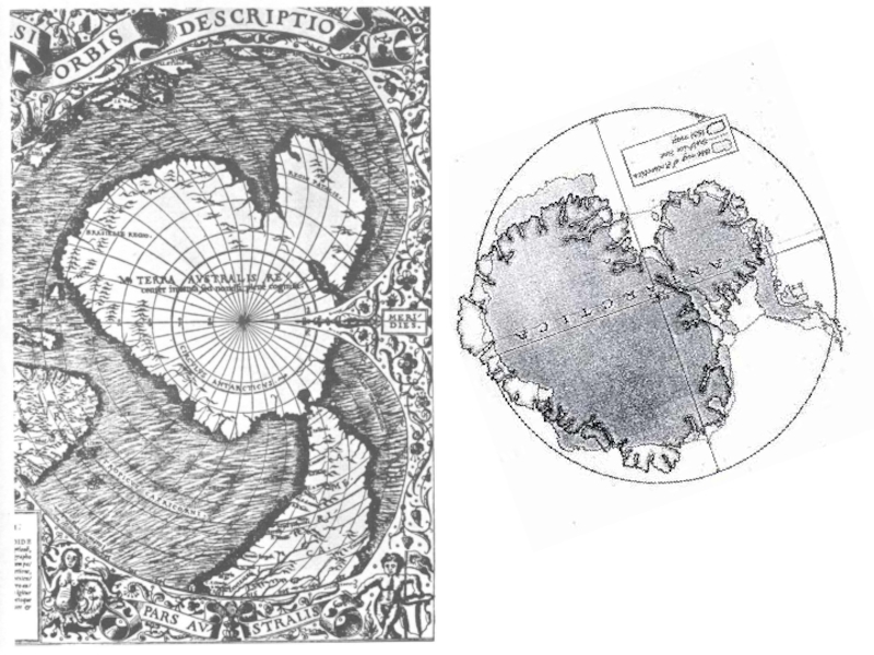
- 9. The Orontius Finaeus Map, 1531
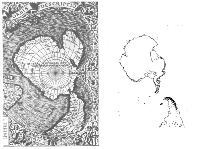
- 10. Antarctica? http://www.goldenageproject.org.uk/112antarctica.php
- 13. Map by Mercator, 1587
- 14. Hendrik Hondius Map, 1630
- 15. A Vicious Circle Without Accurate Navigation, Accurate
- 16. What’s Missing? The Pacific Ocean Isthmus of
- 17. Arm-Waving Looks Persuasive Azimuthal Equidistant Projection Centered on Cairo
- 18. Detailed Comparison Doesn’t
- 19. Azimuthal Equidistant Projection Centered on 0,0
- 20. Orthographic Projection
- 21. Cylindrical Equidistant Projection
- 22. Likely Identification
- 23. Alternative Identification
- 24. Not Antarctica
- 25. Conclusions All Identifications of Antarctica Fail By


Слайд 4The Portolan Grid
Equator and 45N are quite accurate
Map ends just below
45S
Intermediate Roses Might Represent Tropics (23.5 N or S) or 1/8 of a Hemisphere (22.5 N or S)
Intermediate Roses Might Represent Tropics (23.5 N or S) or 1/8 of a Hemisphere (22.5 N or S)

Слайд 5The Portolan Grid
Radiating Lines are Compass Bearings
Meridians and Parallels are perpendicular
This
is a Cylindrical Map Projection

Слайд 6Quality of Cartography
Europe and Africa
Coasts Pretty Good
Rivers Inaccurate
Brazil: Recognizable
North America and
South of Brazil: Very Poor

Слайд 7Interpreting Ancient Maps
Any Ancient Map is Only as Good as Its
Depiction of Well Explored Areas
Things of Practical Use to Mariners (Capes and Islands) Often Exaggerated
Latitude is the Most Likely Parameter to be Accurate; Longitude Largely Guesswork
Imaginary Features Often Incorporated and Gaps Filled In
Things of Practical Use to Mariners (Capes and Islands) Often Exaggerated
Latitude is the Most Likely Parameter to be Accurate; Longitude Largely Guesswork
Imaginary Features Often Incorporated and Gaps Filled In


Слайд 15A Vicious Circle
Without Accurate Navigation, Accurate Maps Weren’t Necessary
Maps Were Largely
Schematic
Without Accurate Maps, there was no Point in Trying to Navigate Precisely
Coastal Charts, on the Other Hand, Were Valuable
Even Into Modern Times, Many Questioned the Need for Accurate Mapping
Without Accurate Maps, there was no Point in Trying to Navigate Precisely
Coastal Charts, on the Other Hand, Were Valuable
Even Into Modern Times, Many Questioned the Need for Accurate Mapping

Слайд 16What’s Missing?
The Pacific Ocean
Isthmus of Panama
Drake Passage
Deep Water: Was Never Dry
Land
No Evidence of Antarctic Ice Connection
Any Indisputable Feature of Antarctica
No Evidence of Antarctic Ice Connection
Any Indisputable Feature of Antarctica


Слайд 25Conclusions
All Identifications of Antarctica Fail
By Modern Standards, Not a Very Accurate
Map
Has Exactly the Inaccuracies Expected for a 1513 Map
For 1513, A First-Rate Work of Naval Intelligence
Turkey Was Not Involved in Atlantic Exploration
Synthesis of Captured Documents
Remarkable Level of Detail for 1513
Has Exactly the Inaccuracies Expected for a 1513 Map
For 1513, A First-Rate Work of Naval Intelligence
Turkey Was Not Involved in Atlantic Exploration
Synthesis of Captured Documents
Remarkable Level of Detail for 1513