- Главная
- Разное
- Дизайн
- Бизнес и предпринимательство
- Аналитика
- Образование
- Развлечения
- Красота и здоровье
- Финансы
- Государство
- Путешествия
- Спорт
- Недвижимость
- Армия
- Графика
- Культурология
- Еда и кулинария
- Лингвистика
- Английский язык
- Астрономия
- Алгебра
- Биология
- География
- Детские презентации
- Информатика
- История
- Литература
- Маркетинг
- Математика
- Медицина
- Менеджмент
- Музыка
- МХК
- Немецкий язык
- ОБЖ
- Обществознание
- Окружающий мир
- Педагогика
- Русский язык
- Технология
- Физика
- Философия
- Химия
- Шаблоны, картинки для презентаций
- Экология
- Экономика
- Юриспруденция
Stratigraphy and Correlation презентация
Содержание
- 1. Stratigraphy and Correlation
- 2. Content Data, Stratigraphy and Models Graphic Correlation Reservoir Architecture and Reservoir Performance Exercises
- 3. Introduction Correlation – the identification of certain
- 4. Introduction Depends on the aims and methods
- 5. Importance of correlation You need to
- 6. Wireline logs (well tops and lithology) are
- 7. Compare the complexity of Helder and Hoorn Fields (Roelofsen et al., 1991) Data
- 8. Wire log data transformation to True Vertical
- 9. Why normalize scales? MD gives thicker
- 10. Caliper – кавернометрия, результатом измерения является кавернограмма
- 11. Different purpose – GR – lithology (sand
- 12. Lithostratigraphy: most widely used (still), allows arrangeing
- 13. Uniformitarianism: The present is the key to
- 14. Law of Superposition: in any sedimentary succession
- 15. Lithostratigraphic unit – a stratum or body
- 16. In this 10X thin section photograph, we
- 17. галит карбонат кальция ангидрит Призматические, брусковидные кристаллы
- 18. The same lithology does not always mean
- 19. Formal lithostratigraphic terms in increasing scale:
- 20. MZ-KZ PZ В строении Западно-Сибирской нефтегазоносной провинции
- 21. Stratigraphic section of Mesozoic rocks of West
- 22. Stratigraphic markers are widespread units or boundaries
- 23. Channel sandstones Reefal limestones (across the body)
- 24. Lithostratigraphy: markers 1. The top of
- 25. Clear wireline log response and good acoustic
- 26. Well №1 shows reduced section because of
- 27. True succession Drilled succession Repeated sections:
- 28. Beware of probable differences in resistivity logs
- 29. Sandstone Siltstone Limestone Conglo-merate Correlate the different
- 30. This is one of possible answers Exercise 1. Lithostratigaphical correlation
- 31. We have decided that the subsurface in
- 32. Biostratigraphic unit – a body of rock
- 33. Biostratigraphical correlation
- 34. Correlate the biostratigraphic markers represented by the
- 35. Exercise 2. Biostratigaphical correlation
- 36. Magnetic minerals in sedimentary rocks tend to
- 37. Магнитное поле Земли или геомагнитное поле — магнитное поле, генерируемое
- 38. Общая магнито-стратиграфическая шкала (англ. general magnetostratigraphic scale) – хронологическая
- 39. Черный цвет - нормальная намагниченность, белый цвет - обратная намагниченность Exercise 3. Magnetostratigraphical correlation
- 40. Exercise 3. Magnetostratigraphical correlation
- 41. Formal chronostratigraphic terms in increasing length of
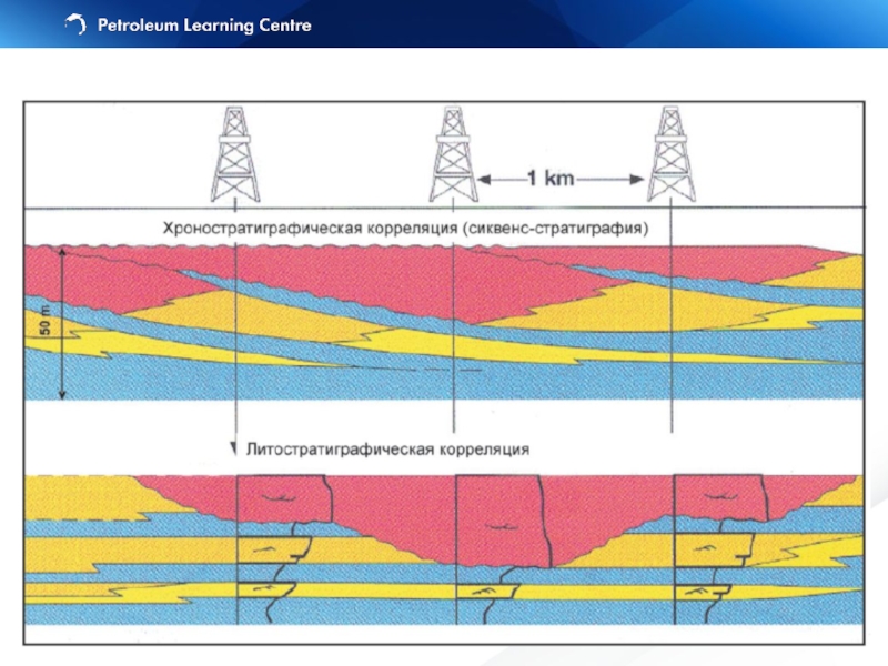
- 42. Chronostratigraphy vs. Lithostratigraphy
- 44. Seismic Stratigraphy Correlation of seismic packages bounded
- 45. Reservoir Limits Stratigraphic pinch-out of reservoir unit (Thompson and Butcher, 1991)
- 46. Пример вероятной рифовой постройки (Черное море, вал
- 47. Эрозионное срезание (erosional truncation) — залегание вышележащих
- 48. Initial Interpretation Final Results Raw Data
- 49. Sequence stratigraphy is the study of genetically
- 50. Eustatic sea level is a distance from
- 51. Accommodation is defined by Jervey (1998) as
- 52. Sediment Deficient
- 53. Excess Sediment
- 54. Upward-fining: bedsets thin, sandstones become finer grained
- 55. Проградационный пакет парасеквенций направлен в сторону бассейна
- 56. Chronostratigraphy vs. Lithostratigraphy Progradational parasequence set
- 57. Chronostratigraphy vs. Lithostratigraphy Retrogradational parasequence set
- 58. Принципиальная схема строения клиноформ неокома Западной Сибири (по А.А. Нежданову и др., 2000).
- 59. “A sequence is a stratigraphic unit composed
- 60. LST = Lowstand Systems Tract: sea level
- 61. TST = Transgressive Systems Tract: sea level
- 62. HST = Highstand Systems Tract
- 63. High sea-level: Flooding surfaces Deposition of reservoir
- 64. The subaerial unconformity is an unconformity
- 65. Stratal elements in Hierarchy
- 66. continental: megasequence supersequence basin: sequence
- 67. continental: megasequence supersequence basin: sequence depositional
- 68. Sequence Stratigraphy Terminology
- 69. Терминология
- 70. Accurate correlations depends on a little knowledge
- 71. Shallow Marine Cook Fm., L. Jur.
- 72. Shallow-marine deposits Exercise 4. Different Environments
- 73. Fluvial deposits Exercise 4. Different Environments
- 74. Exercise 4. Different Environments
- 75. Impossible scenario Realism in correlations
- 76. Stratigraphic relationships are easier to display if
- 77. A correlation panel: equally spaced wells wells
- 78. Correlation panel
- 79. Cross-section
- 80. Fence diagram: actual position of the wells Graphic Correlation
- 81. Block-diagram (well location needed) – either 3-D
- 82. Use the log patterns to correlate, but
- 83. Non-geological features
- 84. Correlating wireline logs
- 85. Flow unit is a mappable portion of
- 86. Flow units concepts: Have the same petrophysical
- 87. Reservoir Architecture and Reservoir Performance
- 88. Layercake – Layered reservoirs: Low permeability contrasts
- 89. Deterministic model can be used for correlation Simple to model Reservoir Architecture
- 90. Deterministic model hardly can be used for
- 91. Connectivity between sand bodies is related to
- 92. Layered architecture (Layercake)
- 93. Layercake Labyrinth Jigsaw Layercake Jigsaw
- 94. Sedimentary structures or stratal architecture (facies models)
- 95. Learning objectives Identify correlation markers Correlate
- 96. It involves: 6: Correlation and hanging 7:
- 97. Дополнительные слайды
- 98. Эрозионное срезание
- 99. Seismic unconformities
- 100. Natalia Kaumova

Слайд 2Content
Data, Stratigraphy and Models
Graphic Correlation
Reservoir Architecture and Reservoir Performance
Exercises

Слайд 3Introduction
Correlation – the identification of certain intervals in one well which
– usually same geological age
– often (but not always) same lithological character
Light tables and computer correlation techniques
Artform rather than science
Geological experience/judgement critical

Слайд 4Introduction
Depends on the aims and methods
Always is a subject of change

Слайд 5
Importance of correlation
You need to correctly correlate lithofacies in the subsurface
identify flow units and to map the distribution, thickness and continuity of reservoir and seal facies
estimate reservoir volume, porosity, permeability distributions and therefore fluid volume

Слайд 6Wireline logs (well tops and lithology) are is a primary (hard)
Biostratigraphic (chronostratigraphic) data
Seismic often is the only way to get an idea of interwell communication pattern
Выделение тектонических нарушений с помощью стандартных временных разрезов, на которых видны смещения осей синфазности отражающих горизонтов, а также затухание амплитуд вдоль субвертикальных линий.
Важность знаний о наличии и положении разломов для разработки месторождений трудно переоценить: они могут являться тектоническими экранами и оказывать решающее влияние на потоки как извлекаемой нефти, так и закачиваемой воды.
Data
 are is a primary (hard) data (usually needs preparation)Biostratigraphic")
Data")
Слайд 8Wire log data transformation to True Vertical Depth (TVD) or TVDSS
KB Vertical distance from kelly bushing to sea level
MD Measured depth. Measured distance along the path of wellbore from kelly bushing to any point in the subsurface
TVD True vertical depth. Vertical distance from kelly bushing to any point in the subsurface
TVDSS True Vertical Depth Subsea. Vertical distance from mean sea level to any point in the subsurface
Альтитуда - высота точки местности над уровнем моря (среднемноголетний уровень моря), определяемая Нивелированием.
Data preparation
 or TVDSS (subsea)KB Vertical distance from kelly")
Слайд 9
Why normalize scales?
MD gives thicker units than TVD, meaning that correlations

Слайд 10Caliper – кавернометрия, результатом измерения является кавернограмма — кривая, отражающая изменение
Mud log - диаграмма удельного сопротивления бурового раствора.
Dipmeter - определение в скважине азимута и угла падения пластов. Азимут и угол наклона пластов определяют в скважине с помощью специального глубинного прибора — пластового наклономера.
Sonic (АК) – измеряет скорость пробега упругих волн в породе. Если известна литология, позволяет рассчитать пористость. Совместно с нейтронным позволяет определить вторичную пористость.
GR – это по сути индикатор глин, и обычный инструмент для корреляции. (но не отличает радиактивные минералы от глины, искажая значение содержания глин).
Wireline Logs

Слайд 11Different purpose
– GR – lithology (sand vs clay)
– Resistivity – saturation
– Sonic – lithology (hard or soft) and seismic markers recognition
– Caliper – sometime lithology and other log data reliability
– Dipmeter – bedding (sometime fractures) orientation; deformation and faults can be recognized
– Mudlog – lithology (cuttings), hydrocarbon shows
Data preparation
– Resistivity – saturation character and quantity– Sonic")
Слайд 12Lithostratigraphy: most widely used (still), allows arrangeing facies, porosity and permeability
Biostratigraphy: fossil assemblages used for correlation and (usually) dating the rocks / раздел стратиграфии, изучающий распределение в осадочных толщах ископаемых остатков организмов с целью выяснения относительного возраста этих отложений.
Chronostratigraphy: using a timelines of sedimentation / раздел стратиграфии, имеющий дело с установлением относительного возраста и возрастных соотношений геологических тел.
Magnetostratigraphy: correlation of zones with the same polarity.
Chemostratigraphy: use of chemical/isotopic markers/ раздел науки на стыке химии и стратиграфии, занимающийся изучением химического состава осадочных пород.
Stratigraphy
, allows arrangeing facies, porosity and permeability zones. / раздел стратиграфии,")
Слайд 13Uniformitarianism: The present is the key to past
Sedimentary rocks are deposited
Sedimentary beds continue laterally until they pinch-out depositionally
Unconformities may represent the greatest amount of geological time
Теоретическую основу стратиграфии составляют два принципа: закон напластования Стено и закон соответствия флоры и фауны ГекслиТеоретическую основу стратиграфии составляют два принципа: закон напластования Стено и закон соответствия флоры и фауны Гексли. Согласно закону напластования, введённому в науку Николасом СтеноТеоретическую основу стратиграфии составляют два принципа: закон напластования Стено и закон соответствия флоры и фауны Гексли. Согласно закону напластования, введённому в науку Николасом Стено в XVII веке, выше лежащие пласты горных пород, как правило, являются более молодыми, чем залегающие глубже. Согласно принципу Гексли, слои, в которых содержатся ископаемые остатки одинаковых видов живых организмов, имеют одинаковый возраст.
Stratigraphic principles

Слайд 14Law of Superposition: in any sedimentary succession that has not be
Walther’s Law: Sedimentary facies occurring in a conformable stratigraphic succession were deposited in laterally adjacent depositional environment. / Только такие фации и фациальные обстановки могут залегать друг на друге в геологическом разрезе, которые в современных условиях лежат рядом.
Stratigraphic principles

Слайд 15 Lithostratigraphic unit – a stratum or body of strata, usually layered,
Lithology – the physical characteristics of a rock, including colour, mineralogy, grain size, textures, structures and so on.
for example: this correlation implies that between these two points this bedding plane is continuous
Lithostratigraphy

Слайд 16In this 10X thin section photograph, we have a Calcareous Sandstone,
Биолкласты. Известняк микро-мелкозернистый с органическими остатками (раковины фузулинид, обломки иглокожих, остатки водорослей,
пр. неопределимый детрит). Увеличение 4х, 10х, николи
Макро- и микроизображения ооидов на поверхности известняка
(Carmel For-mation)

Слайд 17галит
карбонат кальция
ангидрит
Призматические, брусковидные кристаллы ангидрита образуют радиально-лучистые скопления (минерал бесцветный, в

Слайд 18The same lithology does not always mean that the rocks were
Lithology reflects deposition environment
Lithostratigraphy

Слайд 19Formal lithostratigraphic terms in increasing scale:
– Member (пачка) -
– Formation (свита) - mappable unit at the basin scale
– Group (серия) - mappable across several basins
Stratigraphic framework of the region
Пачка — относительно небольшая по мощности совокупность слоев (пластов), характеризующихся некоторой общностью признаков или одним определенным признаком, которые отличают ее от смежных по разрезу пачек в составе свиты (подсвиты) или толщи.
Свита — основная единица местных стратиграфических подразделений, представляет собой совокупность развитых в пределах какого-либо геологического района отложений, которые отличаются от ниже- и вышележащих составом и структурами пород, обусловленных их генезисом, комплексом остатков организмов, пр.
Серия объединяет две или более свиты, образующие крупный цикл осадконакопления и (или) охарактеризованные какими-либо общими признаками: сходными условиями формирования (морские, континентальные, вулканические), преобладанием определенных пород (осадочные, магматические, метаморфические) или их направленной сменой.
Lithostratigraphy
 - smallest locally mappable unit (within")
Слайд 20MZ-KZ
PZ
В строении Западно-Сибирской нефтегазоносной провинции принимают участие метаморфизованный фундамент докембрийско-палеозойского возраста
Западно-Сибирская нефтегазоносная провинция

Слайд 21Stratigraphic section of Mesozoic rocks of West Siberian basin
(Gregory F. Ulmishek)
Stratigraphic
Stratigraphic section of Mesozoic rocks")
Слайд 22Stratigraphic markers are widespread units or boundaries that may be recognized
abrupt lithology change (Bazhen Fm)
platform limestones
shallow-marine sandstone (not basin-wide)
coal beds in deltaic successions
excellent marker – tephra (volcanic ash)
Lithostratigraphy: markers

Слайд 23Channel sandstones
Reefal limestones (across the body)
(Рифовые — обязанные своим происхождением жизнедеятельности
Fluvial coals (sometime are only markers can be used)
Alluvial fan deposits (отложения конусов выноса)
Mudstones (if difficult to distinguish between them).
Lithostratigraphy: non-markers
(Рифовые — обязанные своим происхождением жизнедеятельности прикрепленных ко дну водоема")
Слайд 24
Lithostratigraphy: markers
1. The top of the Bridport Sandstone Formation is marked
recognisable, high radioactivity unit (Inferior Oolite Formation) at 911,6 m.
2. The Gamma Ray and Sonic log have been used for the basis of a Composite Log

Слайд 25Clear wireline log response and good acoustic contract with under- and
методы (НГК, ГГКП) отражают общую пористость пород, а АК – только ее межзерновую часть
Lithostratigraphy: markers

Слайд 26Well №1 shows reduced section because of normal fault penetrated
Dipmeter would
Missing sections: normal faults
(from Tearpock and Bischke, 1991)

Слайд 27True succession
Drilled succession
Repeated sections: reverse faults
(from Tearpock and Bischke, 1991)
Dipmeter would
NOTE: structural features are not only reasons for repeating sections!
Dipmeter would be useful to recognize")
Слайд 28Beware of probable differences in resistivity logs response due to the
Always correlate from the base to top – as the rocks were deposited
Always correlate from the large scale to smaller scale – worry first about formation top and markers
Check for missing and repeated sections
Always correlate both the top and bottom of a bed/formation
Pinching out units indicated by merging lines (< or >)
Never correlate top and bottom of the well – northing common with the stratigraphy
Check for mudstone (shale) color change in the mudlog
Keep in eye caliper log as locating damaged (permeable) rock and probable loss of the other logs quality
Dipmeter sudden response change may indicate faults or unconformity
Volcanoclastic is one of the best marker
Non-geological features (scale change, casing shoes, sonic log cycle skip)
Correlation Guideline

Слайд 29Sandstone
Siltstone
Limestone
Conglo-merate
Correlate the different lithological units represented here
Exercise 1. Lithostratigaphical correlation


Слайд 31 We have decided that the subsurface in the region represented by
What have we just done?

Слайд 32Biostratigraphic unit – a body of rock defined on the basis
Link between lithostratigraphy and chronostratigraphy
Use appearance and disappearance of organisms to date strata
Assuming that the organisms appearance and disappearance are related to evolution and not to environmental change.
Good biostrat depends on:
– environment (marine vs non-marine)
– preservation
– sampling
– type of fauna/flora - use combination
– facies interpretation
Биостратиграфия (от био-... и стратиграфия), отрасль стратиграфии, изучающая
распределение ископаемых остатков организмов в осадочных отложениях с целью
установления относительного возраста и соотношения одновозрастных слоев на
различных территориях. Особенное значение для выделения зон, имеют группы
вымерших организмов с относительно кратким сроком существования, но
достигавшие широкого распространения, значительного изобилия и разнообразия.
Biostratigraphy


Слайд 34 Correlate the biostratigraphic markers represented by the symbols (first and last
Корреляция в стратиграфии — это установление одновозрастности или возрастных соотношений (моложе/ древнее) сопоставляемых стратиграфических подразделений.
Exercise 2. Biostratigraphical correlation
Корреляция")

Слайд 36Magnetic minerals in sedimentary rocks tend to be deposited according to
Earth magnetic field’s polarity change over the time
Today’s polarity referred as a “normal” – black zones (in contrast to the “reversed” – white zones)
Normal polarity
Reversed polarity
(computer simulation, Glatzmaier and Roberts, 1995)
Магнитостратиграфия (палеомагнитный метод) — наука, изучающая расчленение отложений горных пород на основе их прямой или обращенной намагниченности.
Magnetostratigraphy

Слайд 37 Магнитное поле Земли или геомагнитное поле — магнитное поле, генерируемое внутриземными источниками.
Точки Земли,
Подобно тому, как окаменелости и отпечатки организмов, живших в геологическом прошлом, позволяют изучать историю развития органического мира, синхронизировать содержащие их пласты и определять возраст этих пластов, "Окаменелый геомагнетизм" - намагниченность J горных: пород - позволяет изучать историю магнитного поля Земли.
Палеомагнитология изучает магнитное поле Земли геологического прошлого, закрепленное в своеобразных отпечатках этого поля — векторах естественной остаточной намагниченности горных пород, которые фиксируют магнитное поле времени и места образования горных пород. В истории Земли многократно происходили инверсии магнитного поля, когда векторы первичной намагниченности (Jn) менялись на 180°, т.е. северный магнитный полюс становился южным и наоборот.
Magnetostratigraphy

Слайд 38Общая магнито-стратиграфическая шкала (англ. general magnetostratigraphic scale) – хронологическая последовательность магнитозон полярности, привязанная
Осадки формируются с разной скоростью: чем медленнее формировалось отложение, тем тоньше эта магнитостра-тиграфическа зона. И чем быстрее – тем, мощность больше.
Thickness of the zones depends both on it’s duration and sedimentation rate.
 – хронологическая последовательность магнитозон полярности, привязанная к подразделениям Общей стратиграфической")
Слайд 39Черный цвет - нормальная намагниченность, белый цвет - обратная намагниченность
Exercise 3.


Слайд 41 Formal chronostratigraphic terms in increasing length of time:
– Stage - smallest
– Epoch - Upper Jurassic
– Period - longer period (Jurassic)
– Era - Largest time period (Mesozoic)
Chronostratigraphy
Chronostratigraphic unit – a body of rock laid down at the same time.
(Хроностратиграфия (гр. chronos - время, лат. stratum - настил, слой и гр. grapho - пишу) - раздел стратиграфии, имеющий дело с установлением относительного возраста и возрастных соотношений геологических тел).


Слайд 44Seismic Stratigraphy
Correlation of seismic packages bounded by truncations of reflection events
Advantages
-
Disadvantages
- Limited resolution, uncertainty as to what seismic truncations really mean, must be ‘tied’ to well information for lithology and age
Целью сейсмостратиграфического анализа является определение условий и обстановок осадконакопления по особенностям волновой картины на сейсмических разрезах отраженных волн

")
Слайд 46Пример вероятной рифовой постройки (Черное море, вал Шатского)
Пример палеоканалов (русел) (Черное
(Никишин А.М.)
Seismic facies
Пример палеоканалов (русел) (Черное море, вал Шатского)(Никишин А.М.)Seismic facies")
Слайд 47Эрозионное срезание (erosional truncation) — залегание вышележащих отложений выше поверхности эрозии.
Кровельное утыкание (toplap) — срезание моноклинально залегающей толщи сверху более пологой эрозионной поверхностью Кровельное утыка-ние обычно связано с эрозией или перерывом в седиментации.
Согласное залегание — несогласие, когда слоистость параллельна поверхности несогласия.
Подошвенное прилегание (onlap) — прилегание (прислонение) толщи слоев на поверхность, наклонен-ную в ту же сторону, что и слои, но более круто.
Подошвенное налегание (downlap) — несогласие, когда слоистая толща наклонена и книзу утыка-ется в более пологую поверхность.
Основные типы несогласий
 — залегание вышележащих отложений выше поверхности эрозии. Кровельное утыкание (toplap) —")

Слайд 49Sequence stratigraphy is the study of genetically related fades within a
Sequence stratigraphy processes can exert a strong influence on the geometry, continuity, quality and location of reservoir
Sequence Stratigraphy

Слайд 50 Eustatic sea level is a distance from the sea surface to
Relative sea level is a distance between the sea surface and reference horizon such as basement, controlled by:
- Tectonic subsidence or uplift
- Eustatic movement of sea-level
The distance between the sediment/water interface and the sea surface is known as water depth.
Sea-level changes

Слайд 51 Accommodation is defined by Jervey (1998) as "the space available for
This space is the combined product of movement of:
The sea surface (eustasy: global sea level measured from a datum such as the center of earth)
The sea floor (tectonics)
Changes in rates of sediment accumulation
Это то возможное, пространство, где потенциально может накапливаться осадок. Контролируется тектоническими подвижками, климатическими условиями, эвстатическими колебаниями уровня моря, мощностью осадка.
Can be filled with sediments and water
Accommodation space
 as")


Слайд 54Upward-fining: bedsets thin, sandstones become finer grained (commonly culminating in mudstones
Upward-coarsening: bedsets thicken, sandstones coarsen, and the sandstone/mudstone ratio increases upward
Парасиквенс (или парасевенция) – это мелеющая вверх последовательность слоев, ограниченная поверхностями морского затопления. По сути – это регрессивный циклит.
Parasequence
, and the")
Слайд 55Проградационный пакет парасеквенций направлен в сторону бассейна и носит регрессивный характер.
Пакетом парасеквенций назывся последовательность парасек-венций по вертикали, имеющих определенный тип напластования – про-градационный, аградационный или ретроградационный.
Parasequence set


Слайд 58Принципиальная схема строения клиноформ неокома Западной Сибири (по А.А. Нежданову и
.")
Слайд 59“A sequence is a stratigraphic unit composed of a relatively conformable
Parasequences and parasequence sets are the stratal building blocks of the sequence
Sequence Stratigraphy

Слайд 60LST = Lowstand Systems Tract: sea level drop, continental shelf subaeral
Depositional Systems Tracts: LST

Слайд 61TST = Transgressive Systems Tract: sea level rise, maximum flooding surface
Depositional Systems Tracts: TST
, facies boundaries shift")
Слайд 62 HST = Highstand Systems Tract (sometime Regressive Systems Tract):
(Тракт высокого стояния – море стабильно затопляет шельф, перекрывая осадочным материалом. Подошва ТВС/HST– поверхностью максимального затопления).
Depositional Systems Tracts: HST
: sea level rise, stabilizing and")
Слайд 63High sea-level:
Flooding surfaces
Deposition of reservoir close to shore
Reservoir marker events –
Low sea-level:
Exposure of shelf, incision, erosion
Deposition of reservoir in deep water
Reservoir marker events – unconformities
Sequence Stratigraphy

Слайд 64 The subaerial unconformity is an unconformity that forms under subaerial
The correlative conformity is a marine stratigraphic surface that marks the change in stratal stacking patterns from highstand normal regression to forced regression. It is the paleo-seafloor at the onset of forced regression
The maximum flooding surface (is a stratigraphic surface that marks a change in stratal stacking patterns from transgression to highstand normal regression. It is the paleo-seafloor at the end of transgression, and its correlative surface within the nonmarine setting. Alternative terms include: ʻfinal transgressive surfaceʼ, ʻsurface of maximum transgressionʼ.
The regressive surface of marine erosion is an erosional surface that forms typically by means of wave scouring during forced regression in wavedominated shallow-water settings due to the lowering of the wave base relative to the seafloor.
Sequence stratigraphic surfaces


Слайд 66
continental:
megasequence
supersequence
basin:
sequence
depositional systems tract
parasequence set
reservoir:
parasequence
bedset
bed
laminaset
lamina
(adapted from van Wagoner et al., 1990)
Hierarchical
Hierarchical arrangement of stratal elements")
Слайд 67continental:
megasequence
supersequence
basin:
sequence
depositional systems tract
parasequence set
reservoir:
parasequence
bedset
bed
laminaset
lamina
Hierarchical arrangement of stratal elements


Слайд 70 Accurate correlations depends on a little knowledge of the environment of
“In different environments, the geometry and extent of sediment bodies is different”
For example in marine settings sand bodies may extend several kilometres, but in fluvial settings they would rarely be wider than a few hundred metres as each body represents a channel fill.
Correlation and Environmental Interpretation

Слайд 71Shallow Marine
Cook Fm., L. Jur.
Fluvial-deltaic
Ness Fm., M.Jur.
From Livbjerg and Mjos,
From Ryseth, in Collinson, 1989
Correlation and Environmental
Interpretation


Слайд 76Stratigraphic relationships are easier to display if you align the logs
Datum
Graphic Correlation

Слайд 77A correlation panel:
equally spaced wells
wells have been hung
A cross-section:
spacing of
actual arrangement in space of the wells
Correlation panels or cross sections?


Слайд 81Block-diagram (well location needed) – either 3-D image of current geology/geography,
Graphic Correlation
 – either 3-D image of current geology/geography, or interpretations of facies")
Слайд 82Use the log patterns to correlate, but beware of differences caused
Check for mudstone (shale) colour changes in the mudlogs – these indicate changing mudstone formations.
Keep an eye on the caliper log – indicates a loss of quality in the other logs but also shows the location of less compacted or damaged layers.
The dipmeter log is also important – sudden changes may indicate the presence of unconformities or faults.
Natural gamma signature is a good lithological indicator, many formations and markers have distinctive signatures.
Non-geological features such as scale changes, casing shoes and sonic log cycle skips can sometimes mislead the unwary
Correlating wireline logs


Слайд 85 Flow unit is a mappable portion of total reservoir within which
A flow unit zonation integrates geological, petrophysical and production data
Reservoir Architecture and
Reservoir Performance

Слайд 86Flow units concepts:
Have the same petrophysical properties
Recognizable on logs and correlatable
Include non-pay and pay and the fluids therein
Reservoir Architecture and
Reservoir Performance


Слайд 88Layercake – Layered reservoirs:
Low permeability contrasts between vertically stacked layers which
Three (clastic) reservoir types:
Reservoir Architecture
Geologically realistic model from Weber and van Geuns (1990)
")

Слайд 90Deterministic model hardly can be used for correlation – probably stochastic
Reservoir Architecture

Слайд 91Connectivity between sand bodies is related to the proportion of sand
The modelling is complex
Reservoir Architecture

Слайд 92
Layered architecture
(Layercake)
Mixed architecture
(Jigsaw)
Isolated architecture
(Labyrinth)
Architectural Matrix
Mixed architecture(Jigsaw)Isolated architecture(Labyrinth)Architectural Matrix")
Слайд 93Layercake
Labyrinth
Jigsaw
Layercake
Jigsaw
NORTH SEA RESERVOIRS
Primary Recovery
Water Injection
Recovery as a function of geology

Слайд 94Sedimentary structures or stratal architecture (facies models)
Turbidites (Forties), fluvial reservoirs (Brent
Faulting
Seismically resolvable faults (Gullfaks)
Sub-seismic faulting (Thistle)
Combination - faulting and architecture (NW Hutton)
Some fields have no compartments
Measurements techniques:
Formation pressure testers to detect pressure discontinuities and variations in contacts
Geochemistry to detect variations in oil properties
Tracer testing
Compartmentalisation
Turbidites (Forties), fluvial reservoirs (Brent Ness Formation), deltas etc…")
Слайд 95Learning objectives
Identify correlation markers
Correlate lithological units between wells using lithology
Understand how interpretation of depositional environment affects correlation of rock units
Describe the role of different data (seismic, log, biostrat)and models (sequence strat.) on correlation
Describe pitfalls in correlation
Correlation is the step before mapping - Exercises give useful experience

Слайд 96It involves:
6: Correlation and hanging
7: Faulted sections
8: Structural vs stratigraphic cross-sections
Exercise


Слайд 98 Эрозионное срезание (erosional truncation) — залегание
Подошвенное прилегание (onlap) — прилегание (прислонение) толщи слоев на моноклинальную поверхность, наклоненную в ту же сторону, что и слои, но более круто.
Налегание или подошвенное налегание (downlap) — несогласие, когда слоистая толща наклонена и книзу утыкается в более пологую поверхность. Эта поверхность называется поверхностью налегания (downlap surface). Налегание характерно, например, для подошвы клиноформной серии.
Кровельное утыкание (toplap) — срезание моноклинально залегающей толщи сверху более пологой эрозионной поверхностью. Эта поверхность называется поверхностью утыкания (toplap surface). Кровельное утыкание обычно связано с эрозией или перерывом в седиментации.
Согласное залегание относительно поверхности несогласия (concordance) — несогласие, когда слоистость параллельна поверхности несогласия (при этом выше- и нижележащие толщи могут быть между собой несогласны). Выделяется согласное залегание относительно верхней и нижней границы пачки слоев.
Основные типы несогласий
 — залегание вышележащих отложений выше поверхности эрозии. Может")