The mega-transect approach as a basis for development Siberian Environmental Change Network (SecNet) презентация

Содержание

Siberia is not just a land, it is the Universe Located on the vast territories from the Arctic Ocean coastline to its southern borders with Kazakhstan, Mongolia and China, and from

Слайд 1Sergey N. KIRPOTIN, Director of “BioClimLand” Centre of excellence, National Research

Tomsk State University
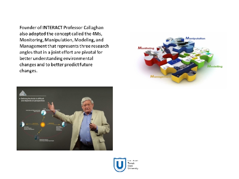
Terence V. CALLAGHAN, Head of Academic Board, TSSW research consultant, Honor Professor, National Research Tomsk State University
kirp@mail.tsu.ru
http://en.science.tsu.ru/centers/research-into-biota-climate-and-landscape/

The mega-transect approach as a basis for development Siberian Environmental Change Network (SecNet)


T-MOSAiC Workshop, Quebec, Canada - 2017


Слайд 2Siberia is not just a land, it is the Universe
Located on

the vast territories from the Arctic Ocean coastline to its southern borders with Kazakhstan, Mongolia and China, and from the Urals to the Pacific Ocean, Siberia is a huge expanse for research with a maximum extension of 2500 kilometers from North to South, and more than 7000 kilometers from West to East. Due to its incredible size, in comparison with other regions, Siberia can be called “the Universe” because any project implemented on its territory is by definition of universal scale.

Turquoise Katun-river in Altai highlands

Frozen mound bogs – palsas in
West-Siberian Northern Lowlands


Слайд 3A special type of
human beings

Unique geography
Unique natural conditions
Unique historical project,

the history of migrations and settlers

A unique role in the events of the twentieth century

Unique network of intelligent hubs

Diversity of natural, geological and biological resources

Network of cities with a unique destiny


Separate cultural space

Region of innovative economy formation


Слайд 4TSSW Mission
To engage Siberia in the World. To engage the World

in the development of Siberia

Climate, landscape, biodiversity, history, cultural, scientific and innovative potential of this unique macro-region are waiting to be explored in the context of global collaboration. We invite you to see Siberia as a new space for your projects, an area of ​​cooperation, and a source of inspiration and new ideas.

Centre of net interactions for TSU participation in the Eurasian research and communication nets

Concentration of knowledge

SIBERIA
on the future
World Map
and its role in the fate of mankind

Discussion of the future Global Agenda with different players from researchers to Governments

TSU expert role

Welcome to the Trans-Siberian intellectual journey!


Слайд 5Earth and natural sciences
Arctic system
Climate change and water recourses Biodiversity
Medicine and

man
«Siberian health»
«Healthy food»
Materials and technology
Materials for extreme conditions
Intellectual and natural resources of Siberia

History, Archaeology, Ethnography
Migration and resettlement
Indigenous peoples Gulag and World War II Anthropology, language, culture
Ethnic and religious
relations
Russian language and traditional culture
Economy
and agriculture
The struggle for resources
Environmentally friendly products
Urbanity and creative industries
Cities strategies
Becoming a knowledge-based economy

Research priorities of TSSW
and possible key subjects


Слайд 6The main activity of TSW focused on creating
— scientific
— educational

intellectual (analytical)
— infrastructural
— innovation
and media

products

Слайд 7Examples of products
● Four-dimensional mapping of Siberia in all subjects of

the Centre
● Analysis, forecasts, expertise relating to Siberia
● Research routes and sites ("invites" and guiding for researchers all over the world)
● Media content on Siberia
● Innovative technology solutions
● Integrated educational programs

Слайд 8Formation of integrated interdisciplinary educational programs
Science
Economics
Society
transfer of
knowledge
and technology
Master programs
“Siberian

and Arctic Studies” and “Siberia: modern development, culture, history (Russian Studies: Siberia)” both in Russian and in English


Слайд 9Affiliate networks


Research nets and collaborations


Слайд 10Mega-science and mega-facilities
Large Hadron Collider (LHC) in Switzerland
The concept

of "mega-science" is usually applied in the field of physics. Extremely expensive and incredibly complex equipment are usually developed for mega-science. It is so expensive that neither one country in the World, even the richest one, can pay for its installation and even work on it. Therefore, different countries and leading scientific centers unite their resources for the development of mega-science. Scientific consortiums are being formed to work on mega-facilities.
For any research organization it is incredibly prestigious to become a member of such a consortium.

Слайд 11unique wetland area;
the world's largest mire Great Vasyugan (area of ​​7.5

million hectares);
40% pristine wetland landscapes of the planet;
¼ carbon stored by the terrestrial ecosystems of the planet kept in Western Siberia;
Global climate-regulation function;
mega- profile (ecological corridor) with a length of 2500 km;
infrastructure and unparalleled access to the region;
all-seasons sampling (spring, summer, autumn, winter), 5-6 expeditions per year;
a combination of methods of ground and remote monitoring, access to the study of genomic research and fine chemical mechanisms of transformation of organic matter;
attractiveness to the international scientific community;
formation of network projects and research consortia.

Western Siberia as a unique wetland area


Слайд 12Western Siberia as a natural mega-facility


Слайд 13New Mega-facility in Western Siberia developed by Tomsk State University,
a

member of INTERACT

Unique mega-transect unparalleled anywhere in the World with an advanced cluster of field stations for conducting surveys, monitoring, sampling, live experiments, and manipulations was founded, extending 2500 km from the high mountain region of Altai in the south and to the deep Arctic Region in the north.


Слайд 14
Siberian Mega-transect
Conceptual pathway
Identifying landscape units
Identifying past changes, characterising baseline conditions,

projecting future changes
Identifying drivers of change
Quantifying consequences of change
Identifying challenges and opportunities and Innovation

Слайд 15INTERACT is an infrastructure project, a circumarctic network of currently 76

terrestrial field bases in northern Europe, Russia, US, Canada, Greenland, Iceland, the Faroe Islands and Scotland as well as stations in northern alpine areas. INTERACT specifically seeks to build capacity for research and monitoring in the European Arctic and beyond, and is offering access to numerous research stations through the Transnational Access program.

Слайд 17Siberian Environmental Change Network (SecNet)
Siberian Environmental Change Network (SecNET) established in

2016 is an open community of educational institutions, research organizations, scientific groups and individual scientists united by the common goal of promoting sustainable development of the northern and polar regions by accumulating comprehensive experience and comprehensive knowledge of the human and natural environment of Siberia and using them to understand and predict socially significant changes and prevention of negative consequences of anthropogenic impact.

The aims of SecNet development are to identify, model and forecast the climate-caused changes in the Siberian environmental state in order to achieve synergy in forming the ecologically friendly management of natural resources, creating new materials and technologies for improving the quality of human life in the region and beyond.

. Blue – Siberian stations


Слайд 18We have brought experts together from throughout Russia and abroad who

study many different fields.

Many others will contribute later


Слайд 19Link world-class international and Russian institutes researching Siberia
Link multiple disciplines and

approaches

Provide a “one-stop-shop” for information on Siberia

Communicate knowledge to educators, researchers, policy-makers and the public

SecNet strategy


Слайд 20SecNET
Siberian Mega-transect (work in progress)
Desert
Mountain
Taiga
Tundra
Steppes
variation in space from the 100

km to 10 m scales

Conceptual pathway
Identifying landscape units
Identifying past changes, characterising baseline conditions, projecting future changes
Identifying drivers of change
Quantifying consequences of change
Identifying challenges and opportunities and Innovation


Слайд 21Approaches to characterise environmental change in the units identified
Baseline establishment
Remote sensing
Surveys,

Herbarium, Ecology, Ethnography

Identifying past change

Characterising current status

Predicting future change

Historical data, Archaeology, geomorphology
Local knowledge, Social Anthropology
Space for time analogues (land use legacies)

Modelling
Simulation experiments
Space for time analogues (land use legacies)


Слайд 22Approaches to identify drivers of change
Biotic e.g. herbivory, succession, species migration


Anthropogenic e.g. land use, fire, pollution

Abiotic e.g. climate, weather extremes, natural fire

Experiments
Correlation analysis
Modelling
Surveys


Слайд 23Launch the Siberian Environmental Change Network (SecNET) at the workshop in

October

2. Transpolar super mega-transect

Siberia BioClimLand
Canadian Mountains
USA NEON
Arctic INTERACT

LEGACY


Слайд 24Join SecNet
If you wish to join the Network as a Partner,

SecNet management encourages you to apply to join. There are currently 10 key participants and they are important part of the Network and the new ones are welcome to apply to join SecNet’s activities, meetings and workshops. You can join by sending a request to one of SecNet coordinators and fill in the Forms:
 
Professor Lyudmila Borilo (e-mail: tssw@mail.tsu.ru)
Olga Morozova (e-mail: dolcezzamia@mail.ru)
Evgenia Kocheva (e-mail: evgenia_kocheva@mail.ru)

Слайд 25Vast areas of palsa bogs with great number of lakes on

watershed surface in northern taiga and forest-tundra zones (photographer S. Kirpotin)


We will now examine elements of a palsa complex as an example of flat-mound bogs or plateau palsas since they have been the most widespread landscape type in the northern part of the north taiga, forest tundra and the southern edge of tundra. The present-day surface of the flat peat mounds exhibits some degradation features consisting in the prevalence of lichens in a vegetation cover and the presence of bare peat spots (3–5% of the surface). Abundant presence of lakes (20–40% reaching up to 80% in the watershed center) is typical for the frozen flat mound complexes of inter-stream areas.

Elements of a palsa complex


Слайд 26The process of permafrost thaw (thermokarst) on the edge of plateaux

palsa at the North of Western Siberia (photographer S. Kirpotin)

Слайд 27Lakes, ponds and drained thaw lake basins
Lakes, ponds and drained thaw

lake basins (khasyreis) are major element of the Northern landscape. These ecosystems are integrators of their surrounding catchment properties including geomorphology, limnology, hydrology, vegetation and permafrost soil dynamics. Many of these properties are strongly dependent of climate doing northern lakes sensitive indicator of it changes (Vincent & Pienitz, 2006).

Слайд 28Endogenous cyclic development of palsas
Scandinavian scientists have made detailed long-term observations

of palsas and have photographed separate stages of this cycle (Matthews et al., 1997; Sollid et al., 1998). These careful observations cover a long period in the formation of separate frozen mounds and interpalsa thawed hollows. The Scandinavians thus developed the concept of the endogenous cyclic development of palsas. But, palsas in Scandinavia and indeed in North America occupy only a small area, so that it is not possible to observe a time series for their development over space.
The situation in Western Siberia is different. Plateaux palsas cover extensive areas in the West-Siberian sub-arctic. All the stages and the smallest nuances of the endogenous cyclic succession process are visible over space in remarkable images. The positions of the edges of the landscape precisely reflect the time series of its development. It is enough just to look at aerial images of landscapes of West-Siberian palsas to see that they live and pulse. You can see the original ‘spill over’ of their elements one to another, making a cycle which is repeated many times.

Слайд 29The first stage of permafrost thaw (thermokarst) on the palsa bog

surface (photographer S. Kirpotin)

Cracks in the lichen cover and drying of the underlying peat during rainless periods are conditions that lead to the formation of some thermokarst areas. Moisture remains in the cracks, and some of them increase in size. They burst when the newly added moisture fast freezes. In such cases the affected areas are large and they develop so quickly that sphagnum mosses and/or sedges do not have sufficient time to settle. Bare soil or attenuated wet peat covered by a thin sheet of Drepanocladus exannulatus or Warnstorphia fluitans can be observed.


Слайд 30The second stage of permafrost thaw (thermokarst) on the palsa bog

surface (photographer S. Kirpotin)

During the second stage of this process, small (0.5-3 m) saucer-shaped round closed dwarf shrub-sedge-sphagnum thermokarst depressions are formed. Thermokarst areas are formed by thawing of the upper part of the permafrost which enlarges the "active layer". This process is supported by relatively warm summer rains. In the aerial photographs such palsas are shown to have a characteristic "porous" surface. The surface appears to have been corroded forming numerous round shaped pits.


Слайд 31Embryonic lake – the third stage of permafrost thaw (thermokarst) on

the palsa bog surface (photographer S. Kirpotin)

The frozen peat found in the mounds gradually thaws during the summer season and the moisture formed as a result of its thawing flows to inter-palsa hollows, streams and lakes. Therefore, once initiated, thermokarst areas can increase in size even during relatively dry periods. If the area is not intercepted by a water flow, it will gradually increase in size and will normally turn into a small round shaped thermokarst lake.


Слайд 32Round lakes as a fourths stage of circle succession of permafrost

degradation (photographer S. Kirpotin)

Слайд 33Khasyrei - drained thaw lake basin, which throw down it’s water

to another reservoir, as a fifth stage of circle succession of permafrost degradation (photographer S. Kirpotin)

In the fifth stage, the lake inevitably turns into a khasyrei – drained thaw lake basin. The most probable origin of a khasyrei is lake drainage to the bigger lakes which are always situated on the lower levels and act as collecting funnels. The lower level of the big lake appeared when the lake accumulates a critical mass of water sufficient for subsidence of the lake bottom due to the melting of underlying permafrost.

Model of thermokarst lake drainage: 1) appearance of thermokarst lake; 2) growing of the thermokarst lake and appearance of small lakes in their neighbourhood; 3) the thermokarst lake takes a critical mass enough for subsidence of the lake bottom; drainage then flows from the small lakes that form.


Слайд 34

During the 2008 expedition carried out within the framework of the

Russian–French network project CAR-WET-SIB we were lucky to observe directly the process of small thermokarst lake drainage into the big one. The water escape from the small lake (N 65° 50′ 04.7″, E 75° 09′ 34.8″) happened in our presence. Our inspection of the small thermokarst lakes situated in close neighbourhoods to the big Shirokoe Lake revealed that all these lakes are placed on a visibly upper level compared to Shirokoe Lake and all of them have generated valleys of drainage toward to the Shirokoe Lake (about 1 km in diameter). Hence, their drainage is only a question of a time.

Big Shirokoe Lake surrounded by small lakes: red arrow: drained lake (it was full of water at the time the image was taken), green arrows: lakes ready to drain (from Google Earth).


Слайд 35As a rule, a big thermokarst lake (like Shirokoe Lake) is

surrounded by a cluster of small lakes. Such a big lake is usually on a lower level and works as a collecting funnel. The lower level of the lake appears when the lake takes a critical mass of water enough for subsidence of the lake bottom due to the melting of underlying rocks. When the critical mass is taken and the lake bottom is given, the lake then becomes a drainage hotbed, and emptied into surrounding smaller lakes. In any case, the bigger lake will be on a lower level compared to smaller ones providing their drainage.
In Western Siberia, water in lakes can’t drain to the subsurface (underlying rocks) as some authors believe (Smith et al., 2005) because the thickness of permafrost is at least 500 m here, being a safe confining bed. The only way for water escape is to lower lakes or hydrological nets.

The mouth of flow from the small thermokarst lake to the Shirokoe Lake (photographer, S. Kirpotin, 2008).

Bottom of the fresh empty lake (photographer, S. Kirpotin, 2008).


Слайд 36Another way of lake drainage could be the lake evacuation to

a river.

Слайд 37Stages of khasyrei development
To sum up, we can suggest four stages

of khasyrei development: freshly drained, young, mature and old. This sequence reflects stages of repeated permafrost heaving from small decluttered frozen mounds to the recovery of palsa plateau due to growing and merging of isolated mounds into khasyrei basins as illustrated in the figure.

Слайд 38Mature khasyrei with yang frozen peat mounds, as a last stage

of circle succession of palsa’s dynamics (aerial photo)


Old khasyrei with recovered plateaux peat mounds, as a last stage of circle succession of palsa’s dynamics (aerial photo)


Слайд 39The khasyrei bottom usually is from one to four metres lower

than the surrounding flat palsas. In late summer cold air frosts go down to the bottom of the lake basin. Permafrost heaving of the lower bog starts again as a result of the temperature inversion and presence of permafrost below the khasyrei bottom. This process is further supported by the settling of sphagnum mosses which provide an effective thermo-insulation and protect embryonic ice lenses from melting. This leads to the formation of a small-mound microrelief, with small (2–5 m) dome-shaped mounds of regular rounded or oval form. Lichens and dwarf shrubs typical for palsas settle on the surface of these small mounds. As the heaving of the permafrost continues, the isolated small mounds merge together and gradually turn, depending on the capacity of the peat deposit, either into a typical palsa plateau or into dwarf shrub and lichen tundra of similar appearance. But even at this stage the edges of the drained lake basin can still be recognised in aerial photographs. Thus, the original cycle of palsa development comes to the end.

photographer Sergey Kirpotin


Слайд 40The scheme of the circle palsa’s succession


Слайд 41Fresh thermokarst subsidence. You can see the dwarf shrubs go under

water (photographer S. Kirpotin, 2004)

At present, the thermokarst is the leading cryogenic process in the subarctic area of Western Siberia and there is a linear character to the cyclic succession of development of palsa. Landslide permafrost melting (Kirpotin et al., 2007) in the West Siberian cryolithozone which, according to our observations, started at the beginning of the twenty-first century, has notably changed the landscape pattern: the number of bog hollows and embryonic lakes has increased as well as the number of drained thaw lake basins (occupied by cotton-grass-sedge-sphagnum swamps) in the southern part of the permafrost zone and the number of expanding lakes in its northern part has increased (Kirpotin et al., 2009).

Landslide permafrost melting


Слайд 42The rest of melting frozen mounds surrounded by rings of water

(photographer S. Kirpotin, 2008)


When we were studying these processes in the Noviy-Urengoy–Pangody area near the Polar Circle in August of 2004, we discovered that the degree of thermokarst activity was unusually increased compared to the early 1990s. Since 2004 thermokarst activity has increased even more and new forms of permafrost thawing have appeared (figure).

Increasing of thermokarst activity


Слайд 43Edges of the big (1 km) lakes (photographer S. Kirpotin, 2004)


Слайд 44Edges of the big (1 km) lake Shirokoe (photographer S. Kirpotin,

2008)

Слайд 45Edge (shore-line) of the small thermokarst lake. You can see the

dwarf shrubs which go under the water, some of them are still alive

Bleuten’s Lake in 2004 (photographer S. Kirpotin, 2004)


Bleuten’s Lake in 2008 (photographer S. Kirpotin, 2008)


Слайд 46Reindeer skeleton - “alive” witness of permafrost thawing
2004


2008 (the same

place)
photographer Sergey Kirpotin


Слайд 47Thermokarst processes increase methane emission, especially from yedomas (ice-rich Pleistocene soils

with a high labile carbon content). Recent discovery of hot spots of methane emission (bubbling) in Siberian lakes is a strong evidence of this possibility (Walter et al., 2006).


Methane bubbles in lake ice on the Siberian North (AP Photo/Nature, Katey Walter)


Слайд 48Small lakes
The small lakes are especially important in the context of

continuing environmental changes and gas emission to the atmosphere. Walter et al. (2007) evaluated the total lake area of Western Siberia using the fine-scale lake database of Lehner and Doll (2004). However, they excluded lakes smaller than 0.1 km2 and therefore significantly underestimated the amount and area of thermokarst lakes (Frey and Smith, 2007). At the same time, numerous small lakes in northern Siberia are particularly important contributors to CH4 ebullition (Grosse et al., 2005). On the other hand, small lakes exhibit the largest fluxes per unit area because their low area to perimeter ratio causes lake-margin carbon inputs via thermokarst erosion and aquatic plant production to be relatively less important (Zakharova et al., 2009).

Methane bubbling from the small lake (photographer – S. Kirpotin)


Слайд 49Western Siberia thaw lakes as mediators of CO2 flux from soil

to the atmosphere


Recently, it has been shown that in Western Siberia, the thaw ponds and depressions with a surface area of less than 1000 m2 exhibit concentration of CH4 and CO2 that is three to ten times higher, and a concentration of dissolved organic carbon (DOC) that is two to three times higher, than those investigated previously in large thermokarst lakes (Shirokova et al., 2012). Significant increase in CO2, CH4, and DOC concentrations with decreasing surface area is pronounced for surface areas that are < 1000 m2, being maximal for small thermokarst depressions with 1–100 m2 of surface area (Figure). These small and very shallow water bodies are extremely abundant, virtually invisible by remote sensing, and absent on available topographic maps or on the fine-scale lake databases (Lehner and Doll, 2004; Downing et al., 2006). These depressions may turn out to be very important mediators of the transformation of old peat carbon into DOC, which is then respired by aerobic heterotrophic bacteria into CO2 (cf., Shirokova et al., 2009).

Figure. CO2 concentrations as a function of water body surface area in Western Siberia, the thermokarst region. The symbol size reflects the value of the uncertainty. Note that all lakes of W Siberia are strongly supersaturated with respect to the atmosphere.


Слайд 50
Fragment of space images Landsat-7 (07.08.1999г.), central
part of PT-5
Simbols:

1 – thermokarst lakes; 2 – dried lakes

Слайд 51

Space image Landsat-1 (10.08.1973) with indicated thermokarst lakes


Слайд 52Fragment of space image Spot-5 ( 20.07.2005)


Слайд 53Comparison of space images
Landsat-1 (10.08.1973) and Spot-5 ( 20.07.2005)


Слайд 54Consequent stages of decrease of lake 9 area
Changes of area of

thermokarst lake 9

Слайд 55Consequent stages of decrease of lake 7 area
Thermokarst lake 7 areas

(red) changes

Слайд 56
S= 5625,0
S= 552,0
LANDSAT -1 (1973)
ALOS (2006)
Thermokarst lakes
Озеро Сихтынэмтор сократилось на 90%


Слайд 57Location of pilot territories in West-Siberian permafrost


Слайд 58Landsat - 1 (scanner MSS), 10.08.1973
Landsat - 5 (scanner MSS), 27.07.1984
Landsat

- 5 (scanner MSS), 26.06.1988
Landsat - 4 (scanner ТM), 01.08.1988
Landsat - 5 (scanner ТM), 20.09.1989

Resurs - F2 (scanner МК 4), 14.06.1993
Landsat - 7 (scanner ETM), 07.08.1999
Landsat - 7 (scanner ETM), 03.08.2001
Landsat - 7 (scanner ETM), 03.07.2002
Spot - 5 (scanner HRV), 20.07.2005
ERS - 2 (scanner SAR), 2005-2008
ALOS (AVNIR-2) 2006-2007


REMOTE SENSING DATA


Слайд 59Through increasing thermokarst activity, two contrasting processes are observed in the

West-Siberian cryolithozone: i) the increase of lake surface due to thawing of lake coast (mainly in the northern part of Western Siberia), and ii) the decrease of the surface area or disappearance of lakes due to water escape to the bigger lakes and hydrological networks. Both processes can be assessed by using space images collected at different times.


The index of relative change of make areas (%) during 36 years of observation at 24 pilot sites of Western Siberia versus geographical latitude. Normalised values of thermokarst lake areas changes depending on latitude.

Results of Research


Слайд 60International projects
Currently our Centre participate in the EU JPI-Climate Project: Climate

impact on the carbon emission and export from Siberian inland waters (SIWA).
This interdisciplinary project link expertise in aquatic biogeochemistry, hydrology and permafrost dynamics with the aim to improve the knowledge of the role of high latitude inland waters in emitting C to atmosphere and in exporting C to downstream coastal regions and how this varies between different climate regimes. We will carry out a comparative study of lake-stream networks across a climate gradient in western Siberia covering a large range of permafrost conditions.
Our partners in this Project are advanced research groups of European quality from: Umeå University, Sweden; University of Aberdeen, UK; University of Toulouse, France.


Слайд 61High riverine CO2 emissions at the permafrost boundary of Western Siberia
Authors:

S. Serikova, O. Pokrovsky, P. Ala-Aho, V. Kazantsev, S. Kirpotin, S. Kopysov, I. Krickov, H. Laudon, R. Manasypov, L. Shirokova, C. Soulsby, D. Tetzlaff and J. Karlsson

Слайд 66Climate change and social consequences, impact on infrastructure
The destructive impact

of permafrost thaw affects not only pipelines, but also other facilities. An inspection has shown that about 250 buildings located in the Norilsk industrial region are suffering from significant deformations associated with the deterioration of permafrost conditions over the past decade, with about 40 residential houses demolished or scheduled for demolition.


Слайд 67Yamal anthrax outbreak could just be the beginning
Animal burials located on

the permafrost also present a danger due to the potential distribution of viruses or hazardous diseases, and their penetration into aquifers, as permafrost thaws.
Burial sites across Siberia with infected animals dug in the past may release spores of anthrax, specialists with Russia’s Academy of Sciences warn.
“The rock and soil that forms the Yamal Peninsula contain much ice. Melting may loosen the soil rather quickly, so the probability is high old cattle graves may come to the surface,” says Mikhail Grigoriev, Deputy Director of the Permafrost Studies Institute under the Academy of Sciences to TASS.
In August 2016 up to 1,200 reindeers were killed either by anthrax or a heatwave in the Arctic district where the infection spread.

The Russian defence ministry deployed biological and chemical warfare troops to destroying the infected carcasses of reindeer in this summer's outbreak. Pictures: Vesti.Yamal, Press Service of Yamalo-Nenetsk Governor's Office.


Слайд 68Prompt warming of a climate in Western Siberia already today has

appreciable economic consequences

Masts that conduct electrical wires are moved from vertical piles driven into the permafrost 30 years ago, to more stable horizontally lying concrete piles.

photographer Sergey Kirpotin


Слайд 69Thank you and welcome to TSSW –
Mega-system for studying boundless

Universe named “Siberia”


Обратная связь

Если не удалось найти и скачать презентацию, Вы можете заказать его на нашем сайте. Мы постараемся найти нужный Вам материал и отправим по электронной почте. Не стесняйтесь обращаться к нам, если у вас возникли вопросы или пожелания:

Email: Нажмите что бы посмотреть 

Что такое ThePresentation.ru?

Это сайт презентаций, докладов, проектов, шаблонов в формате PowerPoint. Мы помогаем школьникам, студентам, учителям, преподавателям хранить и обмениваться учебными материалами с другими пользователями.


Для правообладателей

Яндекс.Метрика